Monday, July 31, 2006

Snakebit On Rainfall. Near Record Heat Ahead.


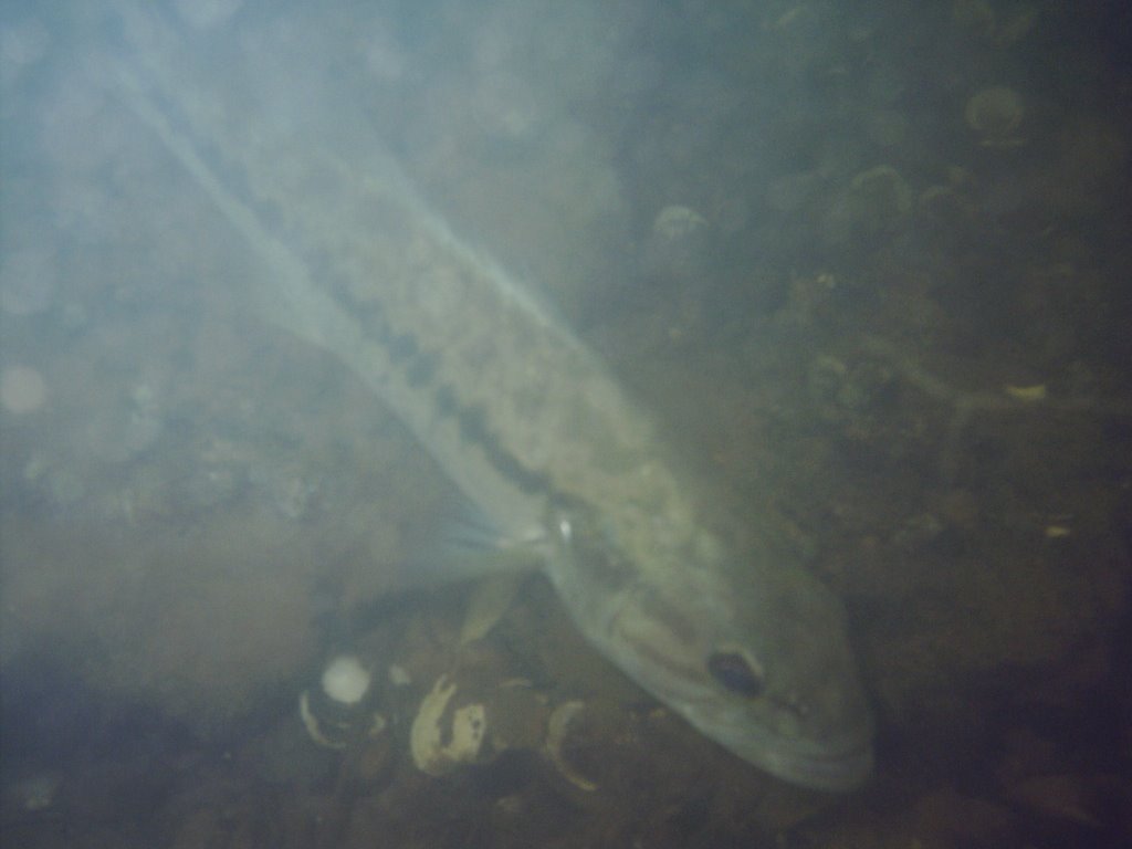
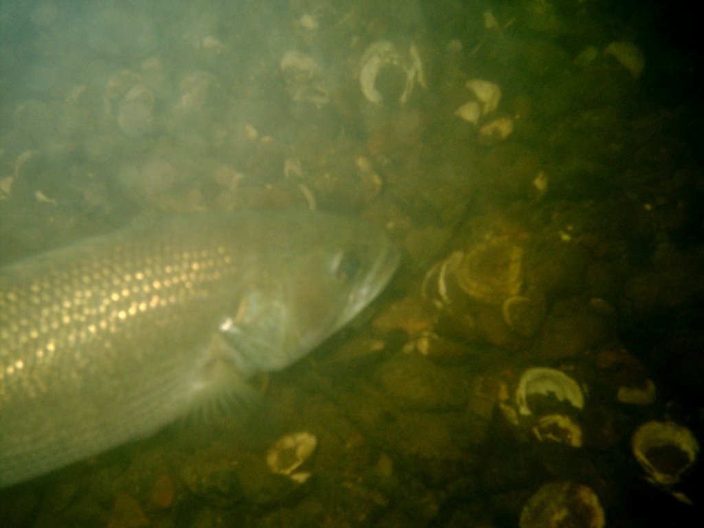
More pictures from the "Crocodile Hunter" canoe trip with my brother, sister, and sister-in-law. I was in front of the canoe and my brother was at the helm. He's the one who spotted this huge water snake. I wanted to get in close enough for some nice pictures, Phil wanted to get close enough so there was a chance the snake might make a lunge at me. The whole time we were talking like Steve Irwin, while we were trying to get snapshots of this "gorrrrrrejussssss" snake. Click on the images to see them full size. The camera really captured the scales nicely.
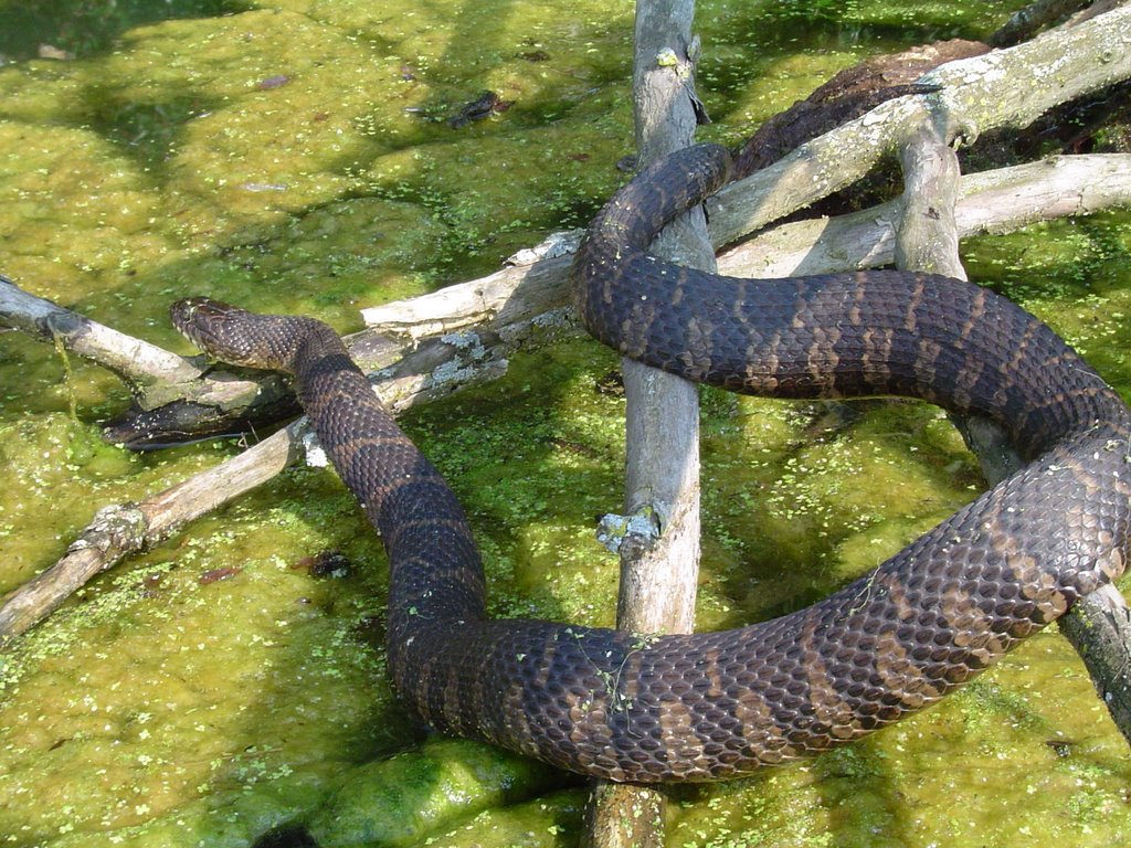
We seem to be snakebit with our rain chances lately. Rainfall in Chattanooga on Saturday was more of a nuisance than a help. Parts of West Tennessee got more than 5 inches on Saturday. Officially only .04" fell Friday and Saturday. And our chances for meaningful rain looks grim this week.
But our chances for near record heat look excellent the next two days. Here are the forecast highs and the record marks:
  • Today: Record 99 set in 1999 - Forecast 96
  • Tue: Record 98 set in 1999 - Forecast 97
  • Wed: Record 99 set in 1987 - Forecast 95
  • Thu: Record 100 set in 1957 - Forecast 94
  • Fri: Record 105 set in 1947 - Forecast 93

I haven't seen sunspot activity discussed in any national publication or website recently, but what I've seen from The Solar and Heliospheric Observatory (SOHO) is interesting. We have a screensaver here in the Channel 3 Storm Alert Center that updates SOHO images of the sun. And the images the last few days have been interesting. There seems to be a lack of sunspots. See the following link for the latest SOHO image: http://sohowww.nascom.nasa.gov/data/realtime/mdi_igr/512/

We are currently in solar cycle 23 which according to the SOHO website began in May of 1996, peaked in April 2000, and is expected to end in early 2007. Or has this cycle ended somewhat early? There is some debate on whether or not sunspot cycles affects the Earth's climate. For a basic description of solar cycles and the Earth's climate check out this website:

http://www.crh.noaa.gov/fsd/astro/sunspots.php

I think it will be interesting to see if this apparent lack of sunspots pops up in any news reports in the near future.

Friday, July 28, 2006

Locking Through....Looking For Some Soakers.


A few more shots of locking through the Chickamauga Dam. Top picture is facing downstream as the gates open, and you can see how big a drop you go through when you look back at yesterday's post. It's pretty awesome. The middle picture is down in the bottom of this man-made canyon. And the bottom picture is looking back as the gates are closing again. Definitely a view I don't get to see very often.
Wow did it heat up quickly yesterday afternoon! Chattanooga zipped up to 96 yesterday once the clouds broke. And I think we'll end up in the lower 90s in most spots this afternoon. But we should see scattered showers and storms late this afternoon into this evening. Then more numerous showers and storms Saturday afternoon. Things should start drying out again on Sunday. Most locations will average 1/2" to 1" today through Sunday evening. But look for some real soakers on a localized basis.
Today: Partly cloudy with a 30% for scattered storms. Highs near 92.

Tonight: Mostly cloudy with 30% for scattered showers and a few rumbles of thunder overnight. Lows in the low to mid 70s.

Saturday: A mix of clouds and sun with a 40% chance for scattered showers and storms. Locally heavy downpours. Highs near 87.

Sunday: Partly cloudy with a 30% chance for hit and miss storms. Highs near 90.

Monday and Tuesday: Steamy with only a 20% chance for isolated storms. Highs both days back into the low 90s.

Have a great weekend!

Thursday, July 27, 2006

I Get To Play Gilligan....Showers Ahead Lil' Buddy.


A couple of weeks ago my friend John Walker needed a little help on his boat. So I told him if he didn't mind someone more like Gilligan than the Professor, I was his guy. You see getting a boat through the Chickamauga Lock is not a one person show. This was a learning experience for me and a chance to look back in a way. I grew up only 12 miles from the Mighty Mississippi and Lock and Dam 13. Every once in awhile we would pile into the car and watch a barge or big riverboat come through the lock. In fact this last summer I had a chance to ride bikes with my sister, my brother, and sister-in-law out to the dam. The Army Corps Of Engineers have a few benches out there and an elevated platform that allows visitors to look down into the lock. And occasionally the barge workers will chat briefly with you. But on the Mississippi the difference between the upper and lower stages is not that dramatic. Maybe 15 feet or so. At the Chickamauga Lock I was surprised at how far the water dropped. I'll try to post those pictures in a day or two. It's pretty amazing, and I'm glad I got to be the first mate on this little journey to downtown Chattanooga.
Once again there were some pretty decent downpours early this morning across the area. In fact it was VIPIR deja vu. Two days ago almost the same areas northwest of downtown Chattanooga were getting locally heavy rain at virtually the same time. Doo-doo-doo-doo. Doo-doo-doo-doo. (Twighlight Zone theme.)
"So Skipper what's ahead?"
"More showers Little Buddy."
The system that absolutely drenched coastal Texas yesterday is weakening as it moves northward. But it's spreading moisture our way. Not enough to drench the area, but quench quite a few lawns and gardens over the next several days. And if we're lucky showery weather will continue with afternoon heat into the first few days of August. The latest 8 to 14 day forecast from the Climate Prediction Center keeps us in above normal rainfall from August 3rd through the 9th. We'll see.
Today - Enough sun through the clouds to get us back up to around 90 this afternoon with a 20% chance for hit and miss storms.
Tonight- Partly cloudy with a 20% chance for a shower or two through the overnight hours. Low near 71.
Friday - 30% chance for scattered showers and storms. Highs near 87.
Saturday - 40% chance for scattered showers and storms. Highs near 86.
Sunday and Monday - Partly cloudy with a 30% chance for hit and miss storms. Highs both days 89 to 91.
Hopefully we end up with average amounts between 1/2" and 3/4". Locally heavier amounts will occur.

Wednesday, July 26, 2006

Historic July Hot Streaks....Is That Water In The Sky?


We saw quite a few fish on our trip to the bottom of the Tennessee River on Sunday. Here's a few shots of the largemouth bass that were swarming us while we were diving. It was a lot of fun watching them.
On this date back in 1952 Chattanooga recorded it's all-time record high of 106. That must have been a nasty hot year. 8 record highs from July 1952 are still on the books, all of them between 101 and 106. Two record highs from 1952 are on the books for the month of May. And there are still 5 record highs on the books from June of 1952. Whew!
Other streaky July years: 4 days still on the books from 1954, 1977, and 1980. 2 record highs remain on the books from 1999. That year we wrapped up July with a pair of 99's, and began August with a record 98. One more record high in August of '99.....100 on the 12th. That was the last year in which we officially hit triple digits in Chattanooga. 4 days were 100 or 101 in August, two more at or above the century mark in September. But those were not records for the 6th and 7th.....1925 was hotter. In fact it was blistering! Check it out all the records from that year that are still on the books:
  • Sept. 5th 104
  • Sept. 6th 103
  • Sept. 7th 104
  • Sept. 8th 100
  • Sept. 9th 102
  • Sept. 10th 98
  • Sept. 11th 96
  • Sept. 19th 100
  • Sept. 20th 99

So even though temps the next several days don't look that bad, these records prove we have quite a ways to go before we start thinking about writing Summer's obituary.

How about the radar look this morning? Showers are gradually spreading across southern and central Mississippi, Alabama, and southwest Georgia. This is enhanced activity on the northern fringes of our Texas storm. The low is over land so it's not expected to become a depression or tropical storm. But it's still going to dump a lot of rain on coastal Texas and Louisiana. And eventually that helps us out with increased rainfall chances.

Today: Partly cloudy and steamy with a 30% chance for some hit and miss storms. Highs near 90.

Tonight: I don't think we can completely rule out an isolated shower overnight, but the chance is only about 20%. Low:71

Thursday and Friday: A mix of sun and clouds with a 40% chance for scattered mainly afternoon and evening showers and storms. High Thursday: 89. High Friday: 86.

Saturday and Sunday: Partly cloudy with 30% chance for hit and miss storms. High Saturday: 88 High Sunday: 90.

The other day I mentioned the woodpecker attack on the bluebird box out back. The entry hole is now bigger and wrens have moved in. Yesterday I discovered once again that all things in nature try to seek a balance. Bluebirds are nesting in the birdhouse on the front porch that last year was inhabited by wrens.


Tuesday, July 25, 2006

Tropics The Topic...Will We Gain Some Rain?

I'm not really sure what's going on with Blogger today. I couldn't post any pictures this morning. So this one is going to be illustrated with the keyboard. And the picture may be a wetter one as we head into the latter half of the week and into the weekend. And the headline says it all....Tropics The Topic.
Take a look at rainfall this year compared to last year and average:
  • Since June 1st - 2006: 6.63" 2005: 12.37" AVG: 7.73"
  • Named Tropical Storms Through July 25th:
  • 2005: 7
  • 2006: 2

Last year's very active tropical season helped double our rainfall compared to this year. As a result, last year we were sitting pretty with a surplus of more than 4 inches. This year "Alberto" and "Beryl" have been too far east to help us out. And when you combine a lack of Gulf moisture with a ridge of high pressure over our heads, you end up with deficits like we have now -1.25" below average since June 1st.....-7.61" since the beginning of the year.

Will we gain some rain?

The overall pattern is looking more like July should over the next week to two weeks. High pressure off the eastern seaboard brings up Gulf steam and scattered showers and storms are the result. Right now a disorganized system south of Texas is stirring up rain that is mainly over the Gulf, but heading north. And some of this flow should feed northeastward towards us later this week. Hefty rains for coastal Texas, thinning out as it heads our way. But at least we get some. So heeeeeeeeeeere we go.

Today: Partly cloudy with only a 20% chance for an isolated storm. High near 90.

Tonight: Partly cloudy, warm and muggy. Low near 69.

Wednesday: Partly cloudy again with only a 20% chance for an isolated storm. High near 91.

Thursday: Partly cloudy with a 40% chance for scattered storms. High near 88.

Friday: Partly cloudy with a 30% chance for scattered storms. High near 86.

Saturday: Partly cloudy with a 30% chance for scattered storms. Highs near 88.

Monday, July 24, 2006

Nice Dip In Temps. Wetter Weather Ahead?


Beautiful weather over the weekend after the very steamy week we just went through. A slight dip in temperatures with full sun made idea conditions for a river dive. Pictured above are dive buddies Ricky Boyd and John Walker. We hitched a ride with Greg Eiche who brought his boat along so we could check out a few new spots in the Tennessee River. During our 1 hour and 25 minutes we saw a lot of largemouth bass. In fact at one point I think we had half a dozen following us. And right at the beginning of the dive we saw one of the biggest bluegills I've seen in a long time. All in all it was a very relaxing time blowing bubbles with some good friends.
What a nice break from the heat. Saturday's high was 84, Sunday 87, and today will end up around 89. This morning's lows are in the lower 60s in most places which is great compared to last weeks morning readings in the 70s. This would be a pretty ho-hum week if it weren't some moisture building in the southern Gulf Of Mexico. The water temperatures are very warm throughout the Gulf, and the overall pattern may become more favorable for development down there the next couple of days so we'll watch it. Even if this does not become a full fledged named system, there should be some hefty rains headed toward coastal Texas and Louisiana. And that rainy weather may turn northeastward far enough to give us some scattered showers and storms later in the week. We'll watch and see.

Today: Mostly sunny with a slight chance for an isolated storm mainly east of I-75.

Tonight: Partly cloudy and muggy overnight with lows around 69.

Tuesday: Partly cloudy with a 20% chance for an afternoon storm. Highs near 91.

Wednesday: Partly cloudy with a 20% chance for an afternoon storm. Highs near 92.

Thursday: Partly cloudy with a 40% chance for scattered storms. Highs around 89.

Friday: Partly cloudy with a 30% chance for scattered storms. Highs around 89.

Saturday, July 22, 2006

Howling Winds Cause Big Problems


There were at least 19 separate reports of wind damage across the Tennessee Valley late Friday night. And many of those simply said, "...trees down county wide."
I want to thank Rozanne Brown of Soddy-Daisy for sending the top three pictures above. And thanks also to Judy and Loyd Boggess of Riceville, TN for sending in the bottom picture.
From what I understand there are still some without power this afternoon. We are fortunate though that no one was hurt. And I'm thankful for those without power that we don't have any upper 90s this afternoon.
South of an Birmingham to Atlanta line it's been real fireworks again this afternoon. There's a lot of ground down there getting very wet today.
Around here most of the Channel 3 Skywatchers have had two day rainfall totals between 1/2" and 1 1/2". Athens had the most so far at 1.7".
The streak is over! After 10 straight days of 90 or above, our high as of 5pm has only been 83. Nice. A few stray showers may yet pop up tonight, but I think most of the rain is over for a day or two. In fact after some low clouds and patchy fog, we should see partly cloudy skies tomorrow with highs in the upper 80s. Near 90 with partly cloudy skies Monday. And then we'll get back into the possibilities for an isolated afternoon storm or two Tuesday and Wednesday. Highs both days back between 90 and 92. Thursday we may see a few more scattered storms with highs near 92 again.
Will things get ugly hot again???
Looking at the pattern coming and what the Climate Prediction Center is forecasting, I'd say make sure you're air conditioning is ready for Heatwave Part deux. Much of the nation may be baking again July 30th through at least the 5th. So I'm glad we got rain while we could. And we'll hope for more ASAP. If not, and the heat bubble comes back for any length of time that 100 mark may finally be reached. I know we were 97 twice last week. But we have not hit 100 degrees officially since September 6th, 1999! That's a streak I'd like to see continue.
Enjoy your Sunday!

Friday, July 21, 2006

Good Old Fashioned "Frog-Stranglers".

I'll be the first to admit that I end up doing some strange things when I'm on vacation. One of them was paddling around in a canoe with my brother, my sister, and my sister-in-law. We had a lot of fun enjoying a beautiful day on the lake. But it ended up getting a little weird when we started trying to sneak up on the resident bullfrogs so I could snap a few close-ups. This shot turned out pretty neat if I do say so myself. Click on it to see it full-sized, and you get the feeling this guy is thinking, "Move along. Can't you see I'm trying to catch a little lunch?" By the way, this little excursion escalated into Steve Irwin imitations as we spoke like the Crocodile Hunter and hunted bigger game with my digital. I'll post those pictures sometime soon.
I think the picture is appropriate for the weather the next two days. Just looking at the Channel 3 Storm Alert Live Doppler radar the last couple of afternoons, you could see good old fashioned "Frog-Stranglers". Those summer downpours that can really douse a relatively small area. Who knows where that phrase comes from? I'm not sure if the origins are down on the farm, but I've heard it over the years in every state that I've lived in. And now I'm doing my part to perpetuate the archaic I guess. Anyway, because the air is saturated with water vapor right now, more of those gully-washer will pop up this afternoon and tomorrow. These kind of conditions are more common this time of year than any other. Relatively light winds above the ground and lots of available moisture. In fact the July 24 hour rainfall record was set on the 20th of July back in 1979 when 4.64" of rain fell. And Chattanooga's all time 1 hour rainfall record was established on July 27th, 1976 when 2.70" of rain fell. But the best news is our string of days with highs 90 degrees or hotter is coming to an end. So far we have had 9....today will make number 10. So heeeeeeeere we go:

Today: Partly cloudy with scattered storms this afternoon. Some could be strong to severe with heavy downpours. Highs near 95.

Tonight: Storms fade, but a few showers could linger overnight. Lows around 73.

Saturday: Scattered showers and storms. Some possibly severe with heavy downpours. Highs around 86.

Sunday: Most of the rain will be South and Southeast of Chattanooga, and moving away during the day. So I think much of Sunday looks o.k.. Highs again around 86.

Monday and Tuesday: Partly cloudy and sticky with highs 90 to 91. And a slight chance for an isolated storm popping up.

As Steve Irwin would say: "Ave a GORE-juss weekend mate!"

Thursday, July 20, 2006

Siesta From The Heat

I had to laugh yesterday afternoon when I looked out the window and saw this squirrel taking a little siesta from the afternoon heat. He was literally sacked out on the railing of the deck. At first I thought he had just climbed up there and was checking out the view. But after about 5 minutes of NO movement, I realized he was sawing logs. So I grabbed the camera. While I was snapping a few pictures of Rocky the dozing squirrel, Dudley figured out something was up.......and soon so was Rip Van Squirrel. He looked at me, looked at Duds and scampered down from the deck and zipped up a tree. I wonder if this was Larry, Curly, or Moe. Earlier this Spring I noticed a mother squirrel leading three little guys around in the treetops. Back then the branches were bare, so I could watch the Three Stooges chasing each other from time to time. And this guy is probably one of them since he's a bit on the small side. Plus I doubt an older animal would pick such a place to snooze. By the way, it was 91 at Casa Benson when this picture was taken. Great napping weather.
A lot of backyard thermometers in valley locations will once again hover near 100 this afternoon. But today a few storms will dot the landscape across the region. Near storms today through the weekend strong, gusty winds will be possible along with big downpours.

Today: Partly cloudy and steamy again. 20% chance for an isolated storm. Highs near 96 in Chattanooga.

Tonight: Storms fade with fair skies overnight. Lows around 72.

Friday: Partly cloudy with showers and storms likely from afternoon on. Highs near 93.

Saturday: Periods of showers and storms. Highs near 83.

Sunday: Partly cloudy with a 30% chance for more showers and storms. Highs near 86.

Monday: Mostly sunny with highs near 90.

Average rainfall amounts Today through Sunday should end up between 3/4" and 1 1/2". But locally heavier amounts will occur. And we'll also have to watch for strong, gusty winds near storms from today through the weekend.
So if Rip Van Squirrel wants a nap and stay dry the next few days he better do it under the deck rather than on top.

Wednesday, July 19, 2006

Cool Stamps Will Be Red Hot.

The mercury official hit 97 at Chattanooga's Lovell Field. Just 3 degrees shy of the record 100 set in 1998! TVA set a power demand record today. So I'm spending the afternoon inside surfing. And I found this little news nugget that ties in well with some earlier posts.
The U.S. Postal Service will begin selling a commemorative D.C. comics stamp set this Friday. And yes, one place where they are being unveiled is at the Massac County courthouse in Metropolis, Illinois. I'm guessing they'll have the media conference right in front of the Superman Statue. Apparently there are quite a few folks who knew these stamps were coming who are waiting to swamp the Metropolis Post Office for the day of release cancellation.
I'll have to admit, I don't get inside a Post Office much anymore. E-mail has pretty much taken care of that. But it looks like I'm missing out by not keeping up with the latest art.

Some More Cool Stamps


"The Wonders Of America" stamp series is out now. The full set is at the top. Here's some close-ups of a few of my favorites. Pretty awesome!

Relief For Outdoor Workers Ahead.


Big projects like the Market Street Bridge make-over take a long time. And it seems like the gang working on it have been making pretty good progress. I spent a little time last Friday "inspecting" their work and snapping these pictures. Honestly, this scale of construction amazes me. They have been hitting it hard almost every day for a year no matter what the weathers like. And the last few days have to be the kind of weather they dread the most. But there's a break coming right around the corner. A weak front will trigger some rain and storms and bring our temperatures back into the bearable range.
Air quality has been an issue lately as well. Another "Code Orange" day with unhealthy levels of Ozone and particles in the air. According to the EPA, days like this effect 50% of the population in the sensitive group. People who have respiratory difficulties like asthma should stay inside as much as possible this afternoon.
By the way, "Beryl" was named the second tropical storm of the Atlantic season late yesterday afternoon. This morning "Beryl" had 40 mph sustained winds and the National Hurricane Center keeps this as a tropical storm. Their official path right now has it moving parallel to the East coast the out over the open North Atlantic. Check it out here:
http://www.nhc.noaa.gov/refresh/graphics_at2+shtml/084323.shtml?5day

Today: Hot & Hazy, 20% for an isolated storm in the Blue Ridge Mountains. Highs around 97.

Tonight: Storms fade, fair skies overnight with lows around 72.

Thursday: Partly cloudy, 20% chance for an isolated storm area-wide. Highs around 95.

Friday: Scattered storms with highs around 92.

Saturday: Scattered showers and storms. Highs around 87.

Sunday: Fewer showers and storms. Highs around 86.

If the models are right this morning, this front will open the door to dry enough air to feel a lot more comfortable the first part of next week. Instead of waking up to lows in the 70s, we could see lows in the low to mid 60s. Still a bit humid, but not nearly what we have had since this past weekend.

Tuesday, July 18, 2006

Cooling Off At The Passage, Cool Front Passage Ahead


Since it's opening last year, The Passage has been a very popular hang-out on hot days. These pictures were taken on Friday when a lot of folks were taking advantage of the cool water around 2 pm. And I'm sure it's been just as packed the last couple of days. And will continue to be packed through the weekend. This steam bath isn't going to abate until Saturday when it looks like a weak front may dip into the area and drop us back to normal. Which for this time of year is still 90. But at least it's not as bad as the low 100s found in Fort Payne, AL and Rome, GA yesterday.
By the way, heat exhaustion is actually MORE likely after a few days of a heat wave than on the first hot day. Why? Because as you lose fluids and salts you may not be replacing them in a balanced way. So the cumulative effect takes a toll on the body. Folks suffering from heat exhaustion may experience dizziness, weakness, and a body temperature rise. It's simply best to just hydrate and take it a little bit easier for the next few days.

Today: Mostly sunny, hot & humid. Light south wind. Highs near 96.

Tonight: Fair, warm and muggy. Low: 72

Wednesday: Hazy, Hot and Humid. Southeast wind 5. Highs near 97.

Thursday: Mostly sunny, hot and humid. Highs near 95.

Friday: Partly cloudy with a 20% chance for an afternoon storm. Highs near 95.

Saturday: Partly cloudy with a 30% chance for some scattered storms. Highs down to around 90.

July is National Ice Cream Month as designated in 1984 by President Ronald Reagan. The third Sunday of the month is supposed to be National Ice Cream Day. But hey, why waste a hot streak by limiting yourself to one dipping day? And what about August? I bring this up because I was just reading online about the eel-like Pout Fish. (Want to see one? Click here: http://oceanexplorer.noaa.gov/explorations/deepeast01/background/dumping/media/dumpingfish.html ) Apparently these critters live in the deep cold waters of the North Atlantic, and are able to do so because of a special protein in their blood. And guess what? Ice cream makers are using a synthesized version of this protein to make our favorite cold treat. Yeah....the eel protein ice cream has half the fat and 30% fewer calories than normal ice cream. Good and good for you. Now if they can only do something about the chocolate syrup that I tend to soak my scoops in we'd be all set!

Monday, July 17, 2006

Too Hot To Fish, Too Hot For Golf......


Country singer Mark Chesnutt may have hit our forecast on the head, "Too hot to fish, too hot for golf, and too cold at home." After some time outside over the weekend working up a sweat, it didn't take much to feel chilly when I got back in the air conditioning. And we don't keep our thermostat all that low. It's just that the steam-bath outside is so tepid that the contrast is huge.
Back in high school I used to hate this time of year. At the time I was working at a grocery store, and much of the day was spent in two places. The dairy cooler or the big freezer in back. So you would go from restocking the frozen food or milk to out in the parking lot in the heat. Back and forth.....all day long. At the end of the day that kind of contrast would really wear on you. So I can imagine how worn out everyone who works outside will be after this week. And how they will be eyeing the calendar and looking forward to October when the fishing and golfing weather will be at it's best. By the way the above pictures were taken at Mermet Springs a dive quarry in Southern Illinois. They have several huge blue cats, and some albino catfish, and a lot of other things to look at underwater including the 727 from the movie "U.S. Marshalls". Check out their website at: http://www.mermetsprings.com According to their website you could start at dive in 84 degree water and cool off nicely near the bottom to around 42 degrees. Brrrrr!!! Too hot to fish.....too hot for golf.....and too cold to dive???

Today: Hazy sunshine, hot and humid. Highs near 96.

Tonight: Clear, warm and muggy. Lows near 71.

Tuesday: Mostly sunny, steamy. High: 97.

Wednesday: Mostly sunny, steamy. High: 96.

Thursday: Partly cloudy, steamy. High: 95.

Friday: Partly cloudy with a slim chance for an isolated storm or two. High: 94.

It's possible that some locations along the Tennessee / North Carolina border get and isolated shower from Wednesday on, but most locations will stay dry. This will be the longest streak of 90 degree or hotter weather we've seen this summer. So far we have had two 6 day streaks and this one has so far lasted 5 days.
  • June 19th through 24th. Hottest: 98
  • June 29th through July 4th. Hottest: 96
  • July 12th through July 16th. Hottest: 95

Climatologically this is the hottest part of the year from July 15th through August 4th. But as we know we can have very hot readings through the second week of September.

Friday, July 14, 2006

Different Kind Of Heat Coming.


This morning was once again "Photo Friday" on Channel 3 Eyewitness News Today. So thanks to two featured photographers, Amanda Rouse of Chattanooga and Elaine Edwards of Hixson. Amanda sent a very cool picture of her puppy "Wags" eyeing a bumblebee. "Wags" is a Papillion, a breed I hadn't heard of before. My father-in-law's dog "Baby" is a great big shepherd mix. And she also chases bees, and snapping at them. I've even seen her catch a couple and very quickly crunch them. So far she hasn't been stung, but sometime soon her hobby is going to come at a price.
I really like Elaine's picture as well. This guy is beautiful, and he's the early bird munching on a meal worm. Right now I think my bluebird box is home to a pair of wrens. For some reason a woodpecker decided to enlarge the hole, so I'm guessing the local bluebirds don't like the looks of the front door. I may replace it with another bluebird box after this summer, but right now the wrens are fun to watch. By the way, the other day I looked out to check on the wrens and just a few feet away was a doe grazing on some of the weeds I mowed through the day before. I ran upstairs to grab the camera, but the auto-focus was fooled by the window and I didn't get very good pictures. It's been awhile since I've seen a deer in the back yard. I'm glad they stop by now and then.
Severe thunderstorms knocked down some trees and powerlines late yesterday. Especially in the Rossville area. During the afternoon hours I heard rumbling all around but no rain at the house. However just before I went to bed another storm was approaching. But as soon as my head hit the pillow I was out. I was going to check the rainguage this morning, but it was pouring when I left so I'll have to wait until this afternoon to see how big a drink the lawn got.
Scattered storms will be numerous again today and tomorrow, but after that it just looks hot. But this will be a different heat than we felt back in June. Sure the highs were in the upper 90s then, but the dewpoints were relatively low. This heat will come with dewpoints 70 and above. In keeping with the Superman theme from the past few days....that's kryptonite for folks who work outside. The steam really steals your strength and stamina. And this will be the Lex Luthor of heat waves heading across the country. Look for a headline making heat wave marching from the Plains today, into the Midwest and East this weekend and early next week.

Today: Hazy sunshine with scattered storms once again. Some with heavy downpours and gusty winds. Highs around 92.

Tonight: Storms fade with patchy fog late. Lows around 73.

Saturday: Partly cloudy early, storms pop from afternoon on. Highs again around 92.

Sunday and Monday: Hazy, hot and humid. Highs both days around 95.

Tuesday: Just a 20% chance for an isolated storm. Highs still around 94.

Temps may fall back to around 90 by next Friday. But for anyone who works outside, this may be the weekend to stay in, rest and relax. Next week is going to be nasty.

Thursday, July 13, 2006

Here' hoping the A/C unit is bullet-proof.


A few final shots from downtown Metropolis, Illinois where Superman is the unofficial mayor. I love the fact that they have the Daily Planet sign and phone booth downtown. You could step inside and then take a few steps down the street and stand behind the Superman cut-out and have your picture taken as the man of steel. And right above is a cool Superman jumping off a ledge, and up, up, and away. I almost didn't go downtown on this trip. Now I'm glad I did, and I hope you enjoyed seeing the sights as well. (Next time I'm going to spend more time in the Superstore though.)
Things are looking fairly soggy for the next few days across the area as scattered storms cover more real estate than in the recent past. But the key here is scattered. Yesterday for example there were only a couple of storms in the area. But one was really dousing the area only about 2 1/2 miles as the crow flies from my yard. And from the house, you wouldn't have even known it rained that close. But average rainfall amounts from today through the weekend are looking like 1/2" to 3/4" on the low side. And 1" to 1 1/2" on the high end.
A couple of years ago we were in a similar pattern in late July and August. And I was one location that missed out every day on afternoon storms. There were also some places in Bradley County like that. Trees and lawns were burnt brown, while most other spots were getting generous downpours. So I hope more spots are hits than misses the next few days.

Today: Hazy sunshine early, then afternoon storms develop. Highs near 91.

Tonight: Storms fade, patchy fog late. Lows near 73.

Friday: A 20% chance for a shower early. 40% chance for scattered storms popping up during the afternoon with highs in the upper 80s to near 90.

Saturday: Scattered storms again with highs near 92.

Sunday and Monday: Partly cloudy with a 30% chance for hit and miss storms. Highs 91 to 94.

I hope I'm not the only one worried about my air conditioner failing. We have the steamiest 6 or 7 weeks of the year to go. Hang in there good 'ol A/C unit.

Wednesday, July 12, 2006

Superman and Super - Humidity. Kryptonite to Comfort.


Some people may not consider comic strips fine art, but I've always enjoyed the illustrations in comic books and the Sunday paper. In fact I probably spend more time than most with the "funny pages" because I enjoy looking at the facial expressions and backgrounds in each panel. As someone who can't really draw, I can appreciate the time someone has put into making sure those details are there. And I sometimes think about the artist who meticulously puts those tiny touches on each character. Tell him that's not fine art. It's fun to see how comics have changed over the years as well. Take a look at early incarnations of Popeye, Snoopy, or Superman. Then look at today's art.

Above are a couple more shots from Metropolis, Illinois and a closer view of a few Superman panels seen from the street. Fun stuff.

From Superman to Super-Humid. This steam is kryptonite to humans who feel their strongest when dewpoints are in the 40s or 50s. If you work or workout outside, you know how these conditions can zap your energy.

We're starting off this morning with typically steamy weather for the second week of July. Some patchy fog across the area right now that will give way to hazy conditions this afternoon. Most areas should stay dry today, but look for more numerous showers and storms Thursday and Friday. We'll still be in the running for hit and miss storms over the weekend, but probably not to the same extent.

Next week is up for debate to some degree. If the heat bubble retreats westward, another little jetstream dip could trim back our humidity some and keep us in a northwest flow aloft. Right now nothing tropical appears imminent in the Gulf or Caribbean.

Today: Hazy and humid with a 20% chance for an isolated afternoon storm. High: 91

Tonight: Partly cloudy with patchy fog late. Lows around 72.

Thursday and Friday: A mix of sun and clouds with a 40% of mainly afternoon and evening thunderstorms. Highs both days in the upper 80s to near 90.

Saturday and Sunday: Partly cloudy with a 30% chance for an afternoon or evening storm. Highs this weekend 92 to 94.

Some WD-40 please. The man of steel could get a little rusty in this kind of steam bath.

Tuesday, July 11, 2006

Super Vacation.


I had a great time the last two weeks on vacation. To get things rolling, I thought I'd stop by Metropolis, IL. It's been a long time since the last time I'd been in Superman's home town, and with the latest Superman movie hitting the silver screen, I thought why not stop in. Years ago the courthouse lawn had a smaller concrete statue of the man of steel. As I recall, the paint was kinda flaking off the statue and it really needed some attention. Now as you can see....WOW! He's made a big comeback. I noticed many of the old businesses are still hanging in there, and today there's a lot of new stores and restaurants. It was a nice way to get the trip off to a Super Start. I'll post a few more snapshots from Metropolis and a few other pics from the road in the days ahead.
It is nice to be back though. And even better to come back to some wetter weather. Sunday evening I had quite a downpour at the house, picking up almost 1 1/4" in about one hour. (And apparently we had enough rain to keep the lawn fairly green while I was gone.) Yesterday though I ended up with nada. Even though the sky was just as dark, and the growling of thunder was nearby, all I saw was the cool breeze moving away from the storm that dumped nearly an inch at Lovell Field. Before this morning's showers, here's where the rainfall tallies stood:
  • Since July 1st: 1.85" +.14"
  • Since June 1st: 4.05" -1.65"
  • Since Jan. 1st: 22.64" -8.01"

Planning outdoor activities the next few days will be problematic due to the scattered nature of the rains. But things should start drying out a tad by the weekend. So here we go.....

Today: Mainly cloudy with a few more showers and storms this afternoon. Highs in the mid to upper 80s.

Tonight: Showers fade with skies becoming partly cloudy late. Some patchy fog will develop by morning with lows around 72.

Wednesday: Partly cloudy with a few hit and miss storms in the afternoon and evening. Highs around 92.

Thursday and Friday: Partly cloudy with a 40% chance for some afternoon storms scattered about the area. Highs 90 to 93.

Saturday and Sunday: Partly cloudy with a 30% chance for an afternoon storm. Highs climbing this weekend to 93 to 95.

Time to fly......lots of e-mail and voice-mail to answer. So up, up, and away!