Tuesday, October 31, 2006

A Warm Halloween Followed By A Bit Of A Chill.

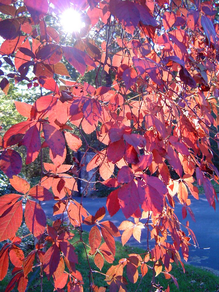
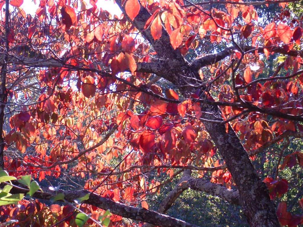
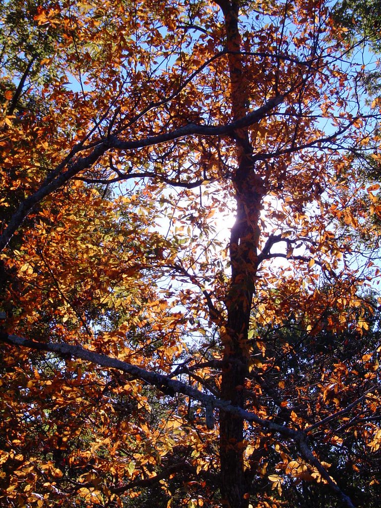
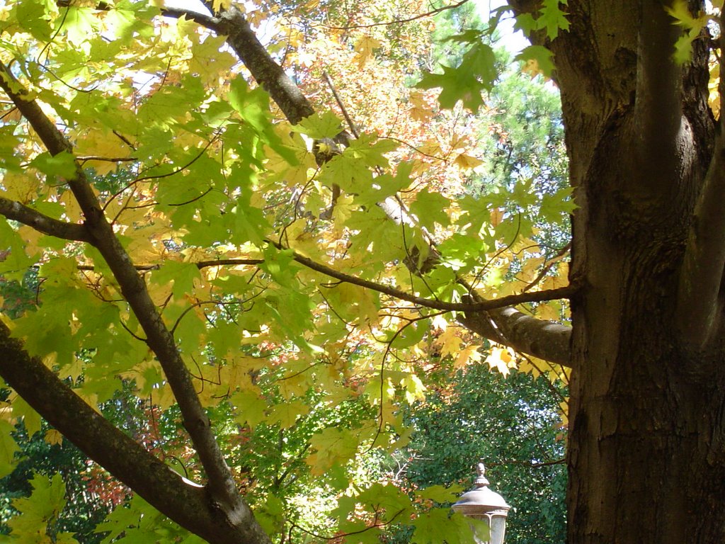
The trees around the Tennessee Valley are spectacular right now. Driving around the area yesterday, I couldn't help but marvel at the patchwork of color gracing the mountains. And up close the color is even better. But the tale of a short color season was being told this morning has I drove into work. A breeze was blowing across Signal Mountain causing a literal blizzard of leaves in my headlights. And in my yard the annual leaf-alanche is only days away. Let mulch-fest '06 begin.
A slow moving cold front will ease into the area late today through Thursday, bringing us some scattered light showers. And then the chilly air arrives this weekend. Nothing drastic, but we will end up seeing highs about 8 degrees below average Friday and Saturday.

Today: Some Sun. 20% chance for a light shower late today. SW wind 5-10. High: 71

Trick Or Treat: 5pm: 69 20% chance for a light shower.
8 pm: 60 30% chance for a light shower.

Tonight: Cloudy with light showers. Low: 52

Wednesday: Mostly cloudy with a few light showers from time to time. High: 66

Thursday: Mostly sunny. High: 62

Friday: Sunny. High: 58

Saturday: Sunny. High: 59

Monday, October 30, 2006

A Real Treat For Now, Then Chillier.

It was nice to see the weather clearing out Saturday morning after a very sloppy Friday. Saturday afternoon Dudley and I took a long stroll to enjoy the breezy and cool conditions. I think he really took pleasure in the added attraction of a new adventure as we took off on a few formerly unexplored side streets. Duds was in full nasal heaven and seemed to really appreciate the many stops I made to snap some pictures. I'll post them in the days to come along with some of your shots that have been e-mailed in. Keep them coming to : tbenson@wrcbtv.com .
Sunday was one of those pure blue days that October is so well known for. I spent a little time in the yard trying to keep up with the carpet of orange, yellow, and red that's now piling up quickly. I began thinking I'm glad I broke out the camera when I did, as rapidly as the leaves are falling. I wish these vivid colors and blue skies would hang around a bit longer.

Today: Sunny and Warm. South 5-10 High: 77

Tonight: Fair and Cool. Light SW Winds. Low: 47

Tuesday: Clouds Increase, Mild. SW Winds 5-10. High: 70

Trick Or Treating: Mostly cloudy at 5pm: 67
30% For A Shower 8 pm: 58
30% For A Shower 10pm: 57

Wednesday: 30% For a light shower. High: 66

Thursday: Partly cloudy, cooler. High: 63

Friday: Mostly Sunny. High: 58

Friday, October 27, 2006

A Soaking, Then Some Wind And A Warm Treat.

Quick post on a very wet morning. Rainfall will continue through early afternoon before tapering off, but we'll have to watch for additional showers and a few storms developing later today. Much of the weekend looks pretty good especially Sunday. Have a great weekend!

Today: Rain and Storms. Rain will be heavy at times. South winds 10 to 15 mph and gusty. High: 63

Friday Night Football: Showery and breezy. Kickoff temp: 59 Game's end: 56
Overnight: Showers Taper Off, cool and breezy. West wind 15 to 20 and gusty. Low: 49

Saturday: Brief early morning shower. Clouds decrease during the day and becoming windy. NW winds 15 to 25 and gusty. High: 59

Saturday night: Fair and chilly. Low: 49

Sunday: Mostly sunny and pleasant. High: 66

Monday: Mostly sunny. High: 71

Tuesday: Good For Ghouls. Partly cloudy. High: 70

Thursday, October 26, 2006

Heavy Rainfall Heads Our Way Once Again.

So far this month we have recorded 4.14" of rainfall which is 1.48" above normal. And many locations should pick up another 2" to 3" before this wraps up very early Saturday morning. October is normally our driest month with just 7 rainy days. This October we have already had 6 days with rain. Add three more today, Friday, and Saturday. Today we're only looking at scattered light showers. But rainfall will be heavy at times Friday and Friday night. So it looks like muddy fields for Friday Night Football fans.

Today: Mostly cloudy with scattered light showers. South wind 5-10 mph. High: 59

Tonight: Rainy Periods, cool. South wind 5 mph. Low: 51

Friday: Rain and a few thunderstorms. Rain will be heavy at times. SW Winds 10 to 15 mph and gusty. High: 60

Friday Night: Rain, heavy at times. Low: 53

Saturday: Early AM Shower, Then Clouds Decrease. High: 59

Sunday: Mostly Sunny. High: 67

Monday: Mostly Sunny. High: 71

Wednesday, October 25, 2006

Frosty Start This Morning, More Rain A Comin'.

Brrrrrr! The heat felt good this morning. The temperature officially dipped to 34 in Chattanooga, but some locations East of the city were quite a bit colder.
  • Blairsville: 25
  • Ellijay, Blue Ridge, and The Bledsoe State Forest: 26
  • Decatur, LaFayette, and Murphy: 28

Looks like that will do it for the really cold mornings for awhile. A new system is gathering steam in the Plains States today, so we should start to get wet by tomorrow. But the heaviest rainfall should occur on Friday. Right now it looks like it will get out of the way by the weekend. But average rainfall amounts Thursday and Friday combined will end up around 1 1/2" in most spots.

Today: Mostly cloudy and cool. SE Wind 5 mph. High: 60


Tonight: Clouds thicken, a few showers late. Low: 41


Thursday: Rain Moves In, Chilly. SW Wind 5-10. High: 53


Thursday Night: Rainy periods. Low: 50


Friday: Rainy and cool. High: 61


Saturday: Partly cloudy. High: 63


Sunday: Mostly sunny. High: 66

Wednesday, October 18, 2006

Springlike Temps Today, Back To Fall This Weekend.

It was a pleasant surprise yesterday to find most of the trees still have most of their leaves. After the windy conditions late Monday night and early Tuesday morning I was a little concerned that many branches would be bare. The colors are really coming on strong now, and barring another big wind event we should have some beautiful foliage to enjoy this year. Send any shots you take this fall to me at tbenson@wrcbtv.com , and we'll show them off on Channel 3 Eyewitness News Today.
Foggy this morning, but turning Spring-like this afternoon. Another front will push through Thursday evening and bring us a light shot of rain and cooler temps this weekend.

Today: Fog burns off by 10am, then mostly sunny and warm. West wind 5 mph. High: 82

Tonight: Fair Skies, patchy fog late. Low: 58

Thursday: Partly cloudy, some scattered storms late. SW 5-10 mph. High: 78

Friday: A morning shower possible, then partly cloudy and cooler. High: 67

Saturday: Mostly sunny, pleasant. High: 70

Sunday: Partly cloudy with a chance for a scattered storm. High: 67

Tuesday, October 17, 2006

Rain And Wind Abate, Up And Down Spate

Here's a shot of the Channel 3 Storm Alert Doppler Radar atop Signal Mountain framed by the reds of Autumn. I took this shot on Saturday while taking the Dud-meister for an extended walk. It will be interesting to see how much color is left after winds gusting to more than 40 mph in the higher elevations knocked out power to parts of Signal and Lookout overnight. Even some valley locations had power interruptions this morning.
As of 7 am we have picked up 1.36" of rainfall just since midnight. Doppler radar rainfall estimates right now range from 3" in Jackson County, AL near Scottsboro, to just .6" in parts of Whitfield County, GA near Dalton.
Rain and winds will wind down as we head through the morning hours, and we should be dry until Thursday afternoon when we could pick up another .25" to .5" of rain. Cool and dry weather is expected for Friday and Saturday.

Today: Rainy and windy early. South 15-25 mph and gusty. Winds settling down this afternoon with a few peeks of sun. High: 71

Tonight: Gradual clearing with foggy areas late. Low: 57

Wednesday: Morning Fog, then partly cloudy and warm. High: 82

Thursday: Partly cloudy start, scattered afternoon and evening storms. High: 74

Friday: Partly cloudy and cooler. High: 66

Saturday: Mostly sunny. High: 68

Monday, October 16, 2006

More Pics From The Nina. Wet Weather Sails In.


I thought I'd post a few more pictures from "The Nina" taken last Thursday downtown. The crew seems to do a great job with the impromptu classroom sessions they do with the kids visiting the boat. Inside the only above deck enclosure, it is very close quarters. I'm still amazed that such a small boat could go so far, with so little in the way of men and supplies. The Nina will be downtown through the 23rd, so you have some time to check out this very accurate replica of nautical history.
Cold mornings this past weekend. Yesterday we tied a record low of 34 in Chattanooga. This morning we're waking up to temperatures some 20 degrees warmer. Two systems combine to bring us hefty rainfall totals the next 48 hours, a surface low over the Gulf, and an upper low over New Mexico. Once we pick up 1.5" to 2.5" of rain, a warm and dry Wednesday is in store for us. Then another front with scattered showers Thursday. Cooler and dry again on Friday.
Today: Rainy periods, cool. SE 10-15+ High: 61

Tonight: Rain, heavy at times. Windy. South 15-20+ Low: 57

Tuesday: Rainy periods, a few storms. South 10-20+ High: 68

Wednesday: Partly cloudy and warm. High: 80

Thursday: Scattered showers. High: 77

Friday: Partly cloudy, cooler. High: 67

Friday, October 13, 2006

Nina In Town. We "Discover" A New World Of Cold


I had the chance to visit "The Nina" yesterday at Ross's Landing, and I really think it's worth the trip to see. Growing up a lot of history didn't do much for me, but the early sailors and explorers always grabbed my attention. Guys like Leif Erikson, Vasco De Gama, Christopher Columbus, Ernest Shackelton, and James Cook. Think about the limited technology they had and what they accomplished by knowing wind and waves, and either surviving or avoiding the storms that came their way. Shackelton's survival and navigation is regarded as one of the most remarkable in nautical history. And recently NOAA scientists equipped with sonar and GPS were stunned by the accuracy of Cook's nautical charts of Prince William Sound in Alaska. They found that he and his crew were amazingly accurate with their depths and positions using only a sextant and a weight and a string to create their maps. And the only places that were wrong were those places that were uplifted by the 1964 earthquake. So when you step aboard "The Nina" replica, you get an idea of what the early sailors had to deal with. The ship is really a boat. I always thought Columbus had huge vessels to make those crossings, but that's just not the case. And his crew slept on the deck with water sloshing back and forth all night long. So check it out if you have a chance. I may post a few more pictures Monday for those who can't make it.
BRRRRRRRRRRRR! Here's a look at some morning lows this morning:
  • 25 Bledsoe State Forest
  • 30 Dayton, Athens
  • 31 Decatur, Sale Creek Mountain
  • 33 Altamont, Prentice Cooper State Forest, Lookout Mountain
  • 39 Cleveland, WRCB-TV 3

Winds stayed up overnight so not many reports of frost this morning, but we should get some frost reports in the morning as Chattanooga drops to the upper 30s by daybreak. Outlying areas will be a bit cooler, but there will be very little if any wind by daybreak. Other than that, a nice weekend ahead so feel free to "explore" the world outside. Some much needed rain moves back in next week.

Today: Mostly sunny, cool & breezy. NW 10-15+ High: 64


Friday Night Football: Clear and Quite Chilly. Kickoff: 58
10pm: 46


Overnight: Clear & Cold with patchy frost. Low: 38


Saturday: Sunny. High: 70


Sunday: Mostly Sunny. 73


Monday: Rain moves in. High: 68


Tuesday: Showers and Storms. High: 76

Have a great weekend matey!

Thursday, October 12, 2006

FALL-ing Temperatures & Patchy Frost?

At several locations yesterday folks were telling me how much they have been enjoying the weather lately. And who could argue? Sure it's been a little dry, but the afternoon strolls with Dudley have been awesome. I took the camera with us the other day to snap some shots of the changing leaves. And things are beginning to look very nice with the reds and oranges really popping now.
The arctic air is plowing southward through the Midwest this morning with a patch of light showers moving southeast out of Kansas. This light rain will be drying up as it heads our way, but we should still see a sprinkle or light shower from this late this afternoon or this evening. Colder air will make for a chilly day Friday, and for Friday Night Football fans. The cold point will be Saturday morning, but right now I think we miss a widespread frost for two reasons, 1) temps just don't get that cold and 2) A light west or northwest wind should stay with us overnight Friday night. But some patchy frost may form is some of the sheltered valley locations. Overall the weekend looks great with a warming trend by Sunday. The first part of next week we should get some much needed rainfall.

Today: After a sunny start, clouds will increase. Then a few light showers across the area late this afternoon into this evening. NW winds 10-15 and gusty. High: 66
Tonight: A light shower early, then mostly cloudy late. Low: 44
Friday: Sunshine returns, but it will be cool and breezy. High: 63 NW winds 10-15 and gusty.
Saturday morning: Patchy frost possible with lows in the upper 30s.
Saturday afternoon: Mostly sunny. High: 69
Sunday: Partly cloudy, warmer. High: 76
Monday: Rain likely. High: 73

Wednesday, October 11, 2006

Some Rain, But Not Nearly Enough. Chilly Though.


Here are a few pictures taken during the Paddlefish Project's first stocking at Loch-Low-Minn near Athens, Tennessee. 70 of these "living dinosaurs" were delivered to this inland diving mecca in late September. This project is part of the Junior Advanced Open Water Class at Choo-Choo Diving. Some of the young scientists were on hand for the big day to release the fish. They have been testing water quality for months as seen in the middle picture. Pictured are Kevin Brown, Kristina Fusco, and Jamie Fox. The Tennessee Aquarium's Rob Mottice brought the paddlefish to McMinn County from a fish farm in Kentucky. He's shown here explaining (To our Matt Johnson, manning the Channel 3 camera.) the electrical receptors the fish have on their paddles that help them locate the plankton they eat. Paddlefish swim with their mouths wide open while they are filter feeding. I hope you got to see the story that ran on Channel 3 Eyewitness News. By the way there is a strong tie-in for this blog fishy weather. Rob and the crew had an very stormy night in Kentucky before they brought the fish here. And they had to slowly drive through several blinding downpours on I-75 as well. We dodged the rain that Saturday that doused McMinn County west of I-75 with more than 4". We were very lucky to stay dry.
Even though we need more rain, there's not a lot of it coming in the next 5 days. Some scattered showers this morning brought only a trace of rain to Channel 3. We should see a bit of sun through the clouds and make it into the mid 70s this afternoon. And our first front arrives later today with some scattered storms. There is some limited potential for a strong to severe storm this afternoon. We clear out tonight and see partly cloudy skies to start Thursday. Late Thursday afternoon into Thursday evening a few more clouds and maybe a sprinkle or two. Then mostly sunny breezy and cooler on Friday. I still don't think we'll see a widespread frost Saturday morning, but it will be pretty cold. Then we warm up Saturday and Sunday. Our next chance for soaking rains comes up Monday through Wednesday next week.

Today: Mostly cloudy with some peeks of sun. Scattered storms this afternoon. High: 76

Tonight: Clouds decrease, and turning a bit cooler. Low: 53

Thursday: Partly cloudy, cool and breezy. A few sprinkles possible Thursday afternoon. Northwest winds 10 to 15 mph and gusty. High: 67

Friday: Mostly sunny, cool and breezy. High: 63

Saturday morning low: 37

Saturday afternoon: Partly cloudy and cool. High: 69

Sunday: Partly cloudy and a bit warmer. High: 74

Tuesday, October 10, 2006

Plenty Of Weather Players On The Field


A few more pictures from this weekend's Tennessee River Rescue dive. There were a few whitecaps on the lake by the time we finished up as the winds never really let up Saturday morning. In the middle my dive buddy for the day John Ingram gearing up, and finally yours truly as "The Creature From The Black Lagoon". For awhile I was thinking the visibility was pretty good compared to last year. Then we moved into an area where we couldn't see a thing. But we were still putting cans in the bag....by feel. Even the dive light didn't do any good. But it was a very fun day and I really enjoyed it in spite of the blustery conditions.
The weather pattern has shifted into high gear. Yesterday snow began flying in Colorado. This morning severe storms are erupting in Texas. There's potential for a lot of weather pictures from across the country the next few days. In fact from hail and wind to snow and sleet a whole cornucopia of weather will occur almost a full month ahead of schedule. The first system heads from the southern plains to the upper Midwest today. The trailing cold from pushes through here tomorrow afternoon into tomorrow evening with some scattered showers and thunderstorms. There's some potential for a few storms to become strong to severe tomorrow. Some cooler air behind front number one Wednesday night into Thursday. Front number two swings through quickly early Thursday packing some wind and chilly air. Behind this front a patch of showers should swing through Thursday afternoon and Thursday evening. Then cold from Friday morning through Saturday. But probably not cold enough for widespread frost Saturday morning. I think temperatures will be marginal for frost in most locations and enough of a breeze stays blowing across the area Friday night that we avoid problems for plants. Then a bit warmer Sunday. But certainly a lot of weather action to look at the next several days.

Today: After a sunny start, high clouds will increase. Southwest winds 5 - 10 mph. High: 82

Tonight: Mostly cloudy and mild with a slight chance for a shower late. Low: 60

Wednesday: Mostly cloudy with scattered storms from afternoon on. High: 77

Thursday: Dry early with scattered showers Thursday afternoon into Thursday evening. Becoming windy and colder. Low Friday morning: 42

Friday: Mostly sunny, but windy and chilly. High: 62

Low Saturday morning: 38

Saturday: Mostly sunny but cool. High: 67

By the way, I told several divers Saturday even though it's chilly today, we're going to be glad we're diving today rather than next Saturday. Even though the water temperature won't change much.....38 Saturday morning instead of the low 50s we had last weekend? Fooogittaaboudit....doze are some divin' temps....not divin' temps if ya know what I mean.

Monday, October 09, 2006

A Great Weekend. Cold Stuff Ahead.


Saturday morning was a chilly one for all the people who volunteered for the 18th Annual Tennessee River Rescue. The air temperature was 53 degrees at 8 am with Northeast winds at 10 mph making it feel like it was in the 40s. But the water was a full 20 degrees warmer and felt downright toasty. Nearly 60 divers came out to clean up this year, and I think the on-shore folks had a great turnout as well. Once again a lot of plastic cups and bottles out there, but fortunately most of the bottles were not broken. My dive buddy John Ingram and I pulled up two bags of garbage, one tire, and one boat ladder. It looked like most of the dive teams were averaging two bags of garbage as well. Think about this, the swimming area near the Chickamauga Dam has been cleaned by divers 3 times in the last year. Last October for the river rescue, last April on Earth Day, and Saturday. And three trailers were pretty full with garbage after Saturday's diving was done. So either this ONE spot was horribly polluted, or people have been very efficient litterbugs since April. I sure hope it's just a pile that's getting smaller rather than a never ending case of laziness. I'll post a few more pictures over the next few days.
Our weather will be swinging up and down rather wildly this week. I'm going to have to put my brother in Northern Illinois on snow watch. They might see some before the week is out. This would be wayyyyyyyyyyy earlier for them. But I can remember some rather chilly nights when you needed a heavy coat trick-or-treating. But I don't recall any with flurries flying. For us, we should see above normal warmth today and tomorrow, scattered storms Wednesday and Thursday, with colder conditions taking over Thursday and Friday. I better have the Fall heating checkup taken care of this week.

Today: Mostly sunny and warmer. High: 80

Tuesday: Partly cloudy and pleasant. High: 82

Wednesday: Clouds increase with scattered showers and storms. Some could be strong to possibly severe. High: 76

Thursday: Scattered showers and a few storms. High: 69

Friday morning's low: 42

Friday: Partly cloudy, cold and breezy. High: Near 60, but a lot of locations may stay in the 50s. With wind, that will feel pretty chilly much of the day.

Friday, October 06, 2006

A Bit On The Windy Side

Another quick sunset shot from last weekend in Southern Illinois. This one seems to have better color when seen full-sized, so click on it and enjoy the rose hues of a late September evening.
Yikes! I had to turn the air conditioner back on at home yesterday afternoon. We hit 88 in Chattanooga, and it was unseasonably steamy as well. But the switcheroo happened last evening as the front that brought us the rainfall pushed through. It's already breezy this morning, and it will be windy this afternoon. Winds should increase to 15 to 20 mph and gusty. Clouds will decrease, but the sunshine will be offset by the northerly windflow.
The rest of the weekend looks fine. I hope you get a chance to enjoy some time outdoors.

Today: Sunshine returns. Windy and cooler. North winds 15 to 20 mph and gusty. High: 75

Friday Night Football: Fair, cool and breezy. Kickoff: 68 10pm: 59

Overnight: Clear and Chilly. Low: 48

Saturday: Sunny and pleasant. Still a bit breezy. North 10 mph. High: 73

Sunday: Mostly sunny. High: 76

Monday: Mostly sunny. High: 80

Tuesday: Partly cloudy. High: 78

Have a great weekend!

Thursday, October 05, 2006

A Little Bit Of Rain, Then A Pleasantly Cool Weekend

There's nothing special about this picture. I just liked the texture of the fungus growing on this oak tree. This is a great month to spend some time in the woods, and this weekend looks awesome for a Fall hike. Color is beginning to show atop Signal Mountain. But I've noticed some of the trees I took pictures of last year that were brilliant red, are more purple and not as vivid this year. But it's still early and these colors could really pop in the days to come.
Our next front is still on schedule to arrive later today and bring a few showers with it. But it still looks like only .1" to .25" of rain on average across the area. Cooler for the weekend, but not drastically so. But this system will be interesting to watch off the Outer Banks of North Carolina over the weekend. It could wind up into quite a storm.

Today: Partly cloudy and warm for most of the day. Then a few showers and storms from late this afternoon into this evening. High: 86

Tonight: Showers early, then mostly cloudy overnight. Low: 59

Friday: Becoming mostly sunny, breezy and cooler. North winds 15 to 20 mph and gusty. High: 75

Saturday: Mostly Sunny and cool. High: 76

Sunday: Mostly Sunny and cool. High: 77

Monday: Mostly sunny and pleasant. High: 80

Mornings over the weekend will be a bit chilly. Most areas should be in the 40s Saturday and Sunday mornings.

Wednesday, October 04, 2006

October Finally Returns This Weekend

There have been plenty of times I haven't had my camera handy and missed something. But just as often I have it ready and the subject fails to show. Each morning about two blocks from the station a deer has been grazing just off the road. Same spot, same time. Yesterday I had the camera ready and the window rolled down, and.........nothing. But an ambulance was zooming by with siren wailing so that might have had something to do with it. Yesterday morning some guardrail work was being done there, so "Bucky" was a no show again this morning. I'll give it one more try tomorrow morning and if he's not there again, I'll cry "uncle" and probably see him Friday morning. I did however manage to have the camera handy over the weekend to capture this beautiful sunset in Southern Illinois.
Man has there been some heat to our northwest. Yesterday Moline, Illinois hit 95 and Peoria, Illinois hit 93. Both readings were all time records for October.
We'll be warm again today and tomorrow, then some cooler readings for the upcoming weekend. And inbetween a little rainfall late tomorrow into tomorrow night. With the emphasis on LITTLE. Most locations will end up with 1/4" or less.

Today: Mostly sunny and warm. High: 86

Tonight: Fair skies with patchy fog late. Low: 60

Thursday: Partly cloudy start, then clouds increase. Scattered showers late. High: 84

Friday: Mostly sunny and a bit cooler. High: 76

Saturday: Mostly sunny and cool. High: 74

Sunday: Mostly sunny and pleasant. High: 77

Tuesday, October 03, 2006

Batman Still Hanging Around, But For How Long?

Click on this picture to see the full sized version and you'll see Batman making his world wide web debut. And batgirl is also in the picture. Sunday afternoon I could hear them chattering at each other, so I grabbed the camera to get some shots of my living barometer. For those who don't know, batman has been living in the vent near the roof of the garage for years. There's a screen on the inside so he can't actually get into the garage, but apparently it's a great place to hang out. In the Spring if it gets warm and stays warm, batman returns. In the Fall if it gets cold and is going to stay cold, batman heads back to whatever cave he winters in. So far we have had a couple of brief chilly snaps, but nothing sustained. And batman is still there. So I'm curious whether his stay in the garage is triggered by the length of day, or maybe his food source drying up. If it's a freeze that kills off whatever insects he feasts on, then his retreat makes perfect sense. I may never know for sure. But I have enjoyed watching him and watching the weather that sends my batty little barometer on his seasonal migration.
The big question I have is how long will we stay unseasonably warm? In the Spring and Fall when you see a big upswing in temperatures, there's usually a big drop down the road. And if the models have the right idea this morning, a big dip in the jetstream may form from the plains into the Tennessee Valley sometime around the 18th of October. Obviously that's in the arena of pure speculation weather-wise, but it will be something to watch since the short term is not that interesting right now. (Will it be the chill that sends batman heading for the hills?)

Today: Mostly sunny and warm. High: 85

Tonight: Fair and cool. Low: 56

Wednesday: Mostly sunny and warm again. High: 86

Thursday: Partly cloudy and warm with a 30% chance for a shower or storm from afternoon into Thursday evening. High: 81

Friday: Mostly sunny and a bit cooler. High: 75

Saturday: Sunny and pleasant. High: 76

Sunday: Mostly sunny. High: 77

Monday, October 02, 2006

Is It Really October?

We spent some time traveling this past weekend up into the Ohio River valley, and it was interesting to see how muddy the Tennessee and the Ohio Rivers were after very heavy rainfall last week up in Kentucky and Southern Illinois. Late last week, there were locations up there that picked up 7" to 10" amounts with some locations in Southern Illinois getting more than 11"! Friday's front allowed some cooler air to spill southward, and that's hitch-hiking weather. Monarch butterflies use the push of air from fronts to help them glide southward this time of year. And there were a lot of them crossing the interstate from north to south this weekend. Look closely in the morning hours and you may be treated to a tree or bush full of them this time of year.
Above is a dogwood tree showing it's Autumn color taken this weekend. Southern Illinois seems to be one to two weeks from peak color. My brother lives at the other end of the state, and it sounds like the color is peaking right now. Around home, I noticed some of the maple trees downtown by Finley Stadium look split vertically. Half green, half yellow. Temperatures are anything but October-like though. In fact you may go back to air conditioning through mid week.

Today: Mostly sunny and warm. High: 85

Tonight: Clear and cool. Low: 55

Tuesday: Mostly sunny and warm. High: 85

Wednesday: Mostly sunny and warm again. High: 86

Thursday: Partly cloudy with a 20% chance for a shower or storm. High: 82

Friday: Mostly sunny and a bit cooler. High: 78