Friday, September 30, 2005

Adios To A Dry September

Thanks to Daniel Siller for sending this beautiful picture of The Southern Belle below the Hunter Museum. (By the way Daniel is a foreign exchange student at Red Bank High School from the Czech Republic. And he's really enjoying his stay in the Tennessee Valley.)
This is a great shot on a crystal clear September evening. Much like the way we'll wrap up the month tonight.
September has been warm and dry in Chattanooga.
We saw a dozen days with highs at or above 90. That helped push the monthly average temperature to about 4 degrees above average.
Rainfall for the month was 2.4" below normal. In fact, this was the third driest September in the last 10 years.
  1. .62" in 1999
  2. 1.47" in 1998
  3. 1.92" in 2005
This morning we woke up to temperatures ranging from 46 in Dayton, Athens, and Lakesite to 52 in Chattanooga. The last time we were this cool in the morning was May 26th when the official low in Chattanooga dropped to 50. A couple of times this summer we had highs in the 70s, but those were cloudy and rainy days. The last time we had full sun and highs only in the 70s was May 25th when the official high was 74.
We should have sunshine from start to finish today with highs into upper 70s this afternoon. Fair to partly cloudy skies Saturday and Sunday with highs in the low to mid 80s. Enjoy a great weekend ahead!

Thursday, September 29, 2005

Searching For My "Tweener"

Our sky may look something like this around sunset today. Clouds should be clearing out as this front continues pushing eastward. The contrast as of 5 am is startling. It's 73 here at Channel 3....63 in Nashville....and 54 in Paducah. Most of the day we'll be in the 60s with breezy conditions. And tomorrow morning expect lower 50s in the city, while outlying areas will drop into the upper 40s. Now THAT'S a front.
In fact it's enough of a change that I spent some time in search of my "Tweener". Everyone has one. It's that jacket that suits you just right in situations like this. Something inbetween going without a light coat, and the days ahead when a heavier coat is necessary. Mine is actually the coat of a wind suit. It's just enough when temps are in the 60s and there's a bit of a breeze. But alas, somewhere since last April my "tweener" has disappeared in the mists of time and one of several closets. During my search I found old mismatched gloves, sweaters with snags, and sweatshirts with holes of various sizes. But no "tweener". So if you see me shivering a bit this afternoon or early tomorrow morning you'll know why. But I am comfortable in the knowledge that this particular jacket will show up one day in the near future. That will be the day I'm searching for the other grey mitten that will keep my hand warm when there's snow and ice.

Wednesday, September 28, 2005

Touch Of Fall A Day Away

This picture was taken at my in-laws place on a sultry Southern Illinois evening back in July. A front had just blown through triggering the storms seen here just to the southeast. I know some neat things can be done with photoshop these days, but I'm not that computer savy. And besides, like Jim Rogers picture yesterday and this one today, sometimes nature doesn't need to be improved upon.
I remember this particular evening because the heat and humidity dropped dramatically. It was a nice break from July's steam. Am I the only one who looks at fronts this time of year in a different way? When a cool air mass pushes through now I look at it suspiciously. Like it's not a welcome visitor, but a harbinger of things to come. I love Autumn, and the crisp mornings and warm afternoons. I don't even mind a little frost around. But I'm much more comfortable in Spring, Summer, and Fall. Winter is a season I struggle with. I guess that comes from growing up in the Upper Midwest when shoveling snow and shivering was possible for 5 or 6 months some years. Cold weather loses it's "magic" when it goes on that long.
Anyway, no frost this time around for us. Scattered showers and a few storms will start moving through from tonight through early tomorrow. Then tomorrow afternoon it will become breezy and cooler. Highs tomorrow afternoon will struggle to get back to 70 in the higher elevations north and west of the city. In Chattanooga we should see a high around 74. The cool point will be Friday morning. Here in the city we'll see lows in the lower 50s, but outlying areas will drop into the upper 40s. Then a pleasantly cool, dry weekend ahead with highs in the upper 70s to lower 80s.
So for now this front will be allowed to pass as a welcome visitor without an icy stare.

Tuesday, September 27, 2005

WOW! What A Shot!

Jim Rogers sent this picture in from his little getaway cabin in Graham County, North Carolina. He says it's his little place to go to watch the grass grow and the fence rust. And obviously it's a great place to watch the sun set. Thanks for sending it Jim. I'm going to put my feet up and stare at it for awhile.
I had a two day rainfall of 2.3" at my house. Many of you saw between .5" and 2". Chattanooga officially recorded .89" in the last two days which puts the monthly rainfall at 1.9". Oddly enough we are now exactly 1.9" below average for September. Normally we would get 4.3" for the month. Last year by this time we had over 8"!
Think about how different this year's weather would have been without the tropical systems bringing much needed rain to the area.
Our next weather maker will be a front that pushes through Wednesday night through early Thursday. I don't see much rain during that time frame though. Most areas should end up with less than 1/10", but some spots could see 1/10" to 1/4". There is cool air behind the front though. Look for highs in the upper 70s to around 80 from Thursday right into the weekend. So October will start off on a cool and dry note. Enjoy it!
And if your sunset doesn't suit you, print out Jim's picture and tape it to the window.

Monday, September 26, 2005

Rita A Welcome Visitor Here.

For some reason Blogger wouldn't accept images this morning, which is disappointing. (I think you're really going to like this picture. Hopefully tomorrow.)
But for us Rita's remnants have not been a disappointment. Here at Channel 3 we have picked up nearly one inch of rain since midnight. So this for the most part has been a gentle, soaking rain for the Tennessee Valley. And we really needed it. But how lucky we are once again. We ended up with a nice rain, no severe weather or flooding, and it all waited until the many weekend events were over. Quite a deal.
Another front promises some scattered showers and storms on Thursday. Until then we dry out from this afternoon through Wednesday.
This front will pack some cool air for us. Nothing drastic, but cool enough to let you know it's Fall and quite a switch from the hot dry weather of last week.
If we haven't turned the corner to truly Autumn-like conditions, at least the blinker is on.

Saturday, September 24, 2005

Rita Lands, Hangs Out

Rita's northern eyewall began coming ashore at Sabine Pass, TX around 3 am EDT this morning with 120 mph sustained winds. A category 3 hurricane at landfall.
Flooding and tornadoes will be problems now for East Texas, Western Louisiana, and part of Oklahoma and Arkansas.
Many of the forecast models including the official NHC path keep Rita's remnants over NE Texas through at least Tuesday.
So our weather should be dry today with just a slight chance for an isolated shower or two Sunday.
That's good news for the Hamilton County Fair today and tomorrow, Wine Over Water this evening, and the Susan G. Komen Race For The Cure Sunday.

Friday, September 23, 2005

Rita's Three Pronged Attack, '26 Cane Remembered


These pictures of the 1926 Miami Hurricane were submitted by a viewer who wanted to remain anonymous. His father lived through this storm and vividly remembers a wrecked store that was open to the public. Residents would take what they needed, and either leave cash in a can or a IOU note. One of these pictures shows that kind of treatment at another store. "If your (sic) destitute its FREE." You should be able to click on these pictures for a larger view. Many thanks for these very interesting scans from a Channel 3 viewer who survived a number of Florida hurricanes including "Donna".
I still think Rita is devastating on three fronts. Heavy rainfall, possibly flooding of various levels for parts of the hard hit "Katrina" areas of Louisiana.
A catastrophic blow to the immediate coastal areas and inland from Galveston to Southwest Louisiana.
And finally a major flood and wind event with tornadoes from Fort Worth, TX along and east of I-45. This would also include SE Oklahoma, SW Arkansas, and a large part of East Texas and West Louisiana.
Unfortunately "Rita" and "Katrina" are dark chapters in American history being written before our eyes.
But let me try to re-state a discussion Jeff, J.R., Kevin, and I got into this morning on Talk 102.3 FM. Which is simply this. Throughout U.S. history people have pulled together to help each other. And I know this will happen again. Every city that has been devastated by hurricane, flood, fire, or earthquake has come back. It takes years and a lot of agony getting there, but there is always a rebound. And I think we'll see the generosity we saw after "Katrina" repeated again soon. (The pictures above should re-inforce the idea that there are always neighbors who reach out to those in need.)

Thursday, September 22, 2005

"Jaw-Dropping"


These two images are from NOAA. The one on the top is "Rita" as a Category 5, the bottom image is "Katrina" as a Category 5. This is the first time in history there have been two category 5 hurricanes in the same year. The term jaw dropping as been used several times to describe the rapid strengthening of "Rita" in the past 24 hours.
By now you have probably heard "Rita" has made the record books in another way, the 3rd lowest pressure in the Atlantic basin.
  1. 888 mb "Gilbert" in 1988
  2. 892 mb "Labor Day Hurricane" in 1935
  3. 897 mb "Rita" in 2005
  4. 899 mb "Allen" in 1980
  5. 902 mb "Katrina" in 2005
As of the 10 am cdt advisory "Rita" was still packing mind blowing 165 mph winds. And here's the NHC latest path: http://www.nhc.noaa.gov/refresh/graphics_at3+shtml/145647.shtml?5day?large
I spoke to my brother yesterday. He's a cool customer. When I asked how he was doing he said, "Well I'm just enjoying a nice sunny day." Actually he was boarding up. And then he was going to help his neighbor board up. They are heading out sometime today, bound for an area southwest of San Antonio. My niece and her daughter are heading up I-45. It's inland and hopefully far enough away, but I'm concerned. I'm praying when this thing is through their homes will be safe. But there will be a lot of people suffering.
It's strange, but just the other day someone from Florida e-mailed asking about Chattanooga's weather. The e-mailer is moving here. I responded by saying we are blessed with a lot of great weather. And while we have our bouts with severe weather and flooding, those events are relatively small potatoes. Fortunately we don't have the threat of a "Jaw-Dropping" hurricane hanging over our heads.

Wednesday, September 21, 2005

Rita Officially Category 4


As of the 8 AM advisory, "Rita" is now a category 4 hurricane with 135 mph winds. Right now it's located 790 miles ESE of Corpus Christi, TX. Movement is West at 14 mph.

Frye's "Katrina" Pics, "Rita" May Go Cat. 5


Robert Frye has been our Channel 3 Storm Alert Skywatcher from Whitwell, TN for years. Robert has always lived and breathed weather, and now he's in college to become a meteorologist. Robert was down on the Gulf Coast at school when "Katrina" hit and he sent these pictures in from Ocean Springs, MS. Robert and his family went there to help some friends who sustained damage in the storm. Robert e-mailed this, "I can't believe how bad it was. Seeing it on TV is one thing, but seeing it real in person is different. WOW."
Unfortunately another disaster looms with "Rita" this morning. The National Hurricane Center candidly admits that this morning there is a lack of data, and although "Rita" is officially Category 3.....it may in fact already be a Category 4. And it may very well go on to attain Category 5 status in the next day or so. There will be fluctuations in strength over the next several days, but there seems to be little doubt that the Texas coast takes a punishing blow from "Rita" as at least a Cat. 3, but maybe a Cat. 4 storm. When I look at a map of Texas, no place is safe really from Beaumont south. But the likely strike zone is between Corpus Christi and Houston / Galveston. The least developed and least populated area is around Palacios, TX which is about halfway between Corpus and Houston.
And a second disaster could take place after landfall. One computer model this morning suggests "Rita" stalls and rains out over northeast Texas which could produce widespread inland flooding across the "Arklatex".
I spoke to my sister-in-law in League City, TX which is in Galveston County. My brother was at work, but he's organized and ready to board up probably today. My niece and her daughter have hotel reservations inland as her place is prone to flooding. Anecdotally, my sister-in-law has a number of beautiful exotic birds. Right now she has a couple of extras. She's bird-sitting for some friends who suffered home damage during "Katrina" at their place in Mississippi. She has been unable to reach them perhaps because the phone situation there is not working yet. At any rate, these birds will likely evacuate with my brother's family in the next day or so.

Tuesday, September 20, 2005

Tropical Troubles Loom Large Again.

Wow and thanks to Doug Loveridge for sending me this gorgeous shot of sunrise off Amelia Island, Florida. Doug and his wife were vacationing there as "Ophelia" was churning away offshore, and that's her in the distance. I often tell folks it's a great place to vacation. Nice beaches, not as heavily traveled as some other places, and if you can swing it after Labor Day you have the whole place to yourself. But "Ophelia" has eaten away a lot of beach from Florida into North Carolina. And my guess is the only folks hearing about the cost of that erosion will be residents near the coast. The price tag of "Katrina" and the future price tag of "Rita" will over shadow what's happened with "Ophelia". Right now there's only two real questions with "Rita". How strong will she get? And who gets smacked this time? There doesn't seem to be much doubt that "Rita" will go Cat. 3, but will she be stronger than that at landfall? It's hard for me to believe we could have two Cat. 4 landfalls in one year in the Gulf, but who knows? In the strike zone: Houston, Galveston, Palacios, down to Corpus Christi. A ton of coastal development and barrier islands potentially in trouble. Last August I was in Galveston and they keep building on the southern end of the island where there's no seawall protection. Most people living there today have never been through a big storm. "Katrina" will hopefully serve as notice that evacuation notices need to be heeded. My oldest brother lives in League City, TX. I know he watches the tropics closely, but I'm going to call just in case. He keeps all the necessary "batten down the hatches" stuff handy. Even if Houston doesn't get a direct hit, it's a city that can see a lot of flooding if "Rita" ends up close enough. My nieces place has had problems in the past. Here's the latest NHC Path for "Rita": http://www.nhc.noaa.gov/refresh/graphics_at3+shtml/084912.shtml?5day?large
Here on the home front, we may see a storm or two this afternoon and evening. But then the rest of the week looks very warm and dry. Yesterday we hit 91, marking the 8th time this month we've been at or above 90 degrees. That's more 90 plus days than we had in June! And we have a chance to be near or above 90 every day through Sunday. Our average high is 82.

Friday, September 16, 2005

A Different "Katrina" Rescue Story Surfaces


Photos Courtesy: NOAA

Dolphins have always fascinated me. As a kid I loved the t.v. show "Flipper", and one of my favorite view-master sets was the three reels of "Flipper". My folks took us to the Brookfield Zoo in Chicago when I was seven or eight. I can only vividly remember two things; the mandrills colorful faces and the dolphin show. In my mind I can still see the dolphins gracefully leaping to amazing heights.
I know there are those who believe dolphins and beluga whales shouldn't be held in captivity. I respect their feelings, but personally I think we learn to love animals like this by seeing them first hand.
So seeing the Marine Life Oceanarium in Gulfport, MS left in shambles by Hurricane "Katrina" is heart breaking.
But one bright spot is an ongoing rescue mission. 8 formerly missing bottlenose dolphins were found doing o.k. in the Mississippi Sound. They had been swept out of their tanks by an estimated 40 foot wave. If only they could talk to us, what a story they must have. 2 have been brought to a hotel swimming pool to be fed and nursed back to health. The other 6 will be rescued as soon as possible. To follow this amazing story of animal survival check out these two links: NOAA NEWS http://www.noaa.gov and The Marine Life Oceanarium's website: http://www.dolphinsrus.com
One day I hope to dive with some dolphins in the wild. I would love to watch them and hear them first hand.
How about this rain today?
After more than a week without, these storms are putting out some serious rainfall. Some storms have been dropping 1/2" to 1" per hour this morning. As of early this morning doppler radar estimates that areas north of Chattanooga have already seen 2" to 3"! And not a moment too soon for a lot of people.
But this front will pave the way for a wonderful weekend across the region. Still warm, but comfortable with big swings in temperatures. We'll go from upper 50s in the morning to mid and upper 80s during the afternoon. Enjoy!

Thursday, September 15, 2005

Whistling In The Trees

This is the infamous river birch tree I mentioned a few posts back. It's the one the hornets built their nest under. Yesterday I was coming back in from getting the mail and I snapped this picture with the phone camera to show how yellow the leaves are. The resolution of this image doesn't do the story justice. More than half the tree is yellow from the recent mini-drought.
Today marks day 16 without any rain. But AHA! As of 9:20 am this morning a few itty bitty showers are popping up on the VIPIR and the Channel 3 Storm Alert Live Doppler Radar. There will be more tonight and Friday, but amounts generally look light. Most areas will see 1/4" or less, but some isolated locations could see up to 1/2". I'm hoping for at least 1/4" in my yard. If we miss out at the official rainguage at the airport, you start to wonder if this will end up being one of the driest Septembers ever. The benchmark was set in September of 1879 when a paltry .04" was recorded.
When it's that dry you can hear a whistling in the limbs according to my good friend Jed Mescon.
He'll tell you that's the trees calling the dogs.

Wednesday, September 14, 2005

What In The World? - Revisited


This post is just for fun. When I was a kid I spent almost all my time outside. I mean from first light until well after dark. Especially in the summer. I was always out catching bugs, toads, frogs, and occasionally snakes. To this day I'm fascinated by the natural world. I think my mom recognized this early on, and I had books on fossils, fish, birds, and mammals. And she also kept a running subscription for me to National Geographic World magazine. The first page I would look for was the "What in the world?" photo section. (This morning I did a quick search and found out it's now available online. http://www.nationalgeographic.com/ngkids/ )
These days I spend my time looking at satellite images trying to figure out, "What in the world is going to happen with the weather?" But there are so many satellite images that are mind boggling. And I know I'm not just being a weather geek. When I find something striking and show it to someone else, they usually are impressed by the views NASA provides. (Or their just humoring the weather geek.)
So just for fun, take a look at the images above. If you are wondering, "What in the world is that?" The first one is a composite image by Steven Running, MODIS Land Group Member, University of Montana. It's the leaf area index. Basically a baseline measure to see how the Earth's land surfaces change over time.
The second image is courtesy NASA/GSFC/LaRC/JPL, MISR Team. This one shows clouds being swirled by airflow in the arctic near Norway. Really beautiful stuff. For more amazing images check out the MODIS image library at: http://modis.gsfc.nasa.gov/gallery/index.php#
We may finally break our dry stretch tomorrow and Friday. The weather is finally moving again as "Ophelia" is lifting northeast this morning, and a front is sagging southeast towards us. Models indicate some places from Chattanooga and points to northwest could see 1/4" to 1/2". But I don't think most of us see that much. Still it's the best shot we have. And this weekend will be dry and comfortable.

Tuesday, September 13, 2005

Fishy Taunt, Fishery Failure, Soon to Be Fish Storm


Let's start with the fun stuff today. These pictures were taken at the Haigh Quarry in July. I had a great day of diving with two of my brothers, my brother-in-law, and my nephew. There's a lot of territory to explore at this place, and tons of fish and other underwater surprises. I hope to get back there again some day, hopefully with the same group of dive buddies. Check it out at: http://haighquarry.com
I'm posting these pictures as a fishy taunt. I'm hoping to prod one of my brothers into loading his gear up and coming down to dive around here. Right now we wouldn't need the 7mm suits we wore up there. (Which we really didn't need that day either.)
In the wake of hurricane "Katrina" the U.S. Commerce Secretary announced a formal declaration of a fishery failure in the Gulf of Mexico. The value of the fish, shrimp, and oyster operations in the Gulf is estimated at $700 million per year. NOAA says there are 432 federally permitted fishing vessels in Alabama; 3,738 in Florida; 1,033 in Louisiana, and 351 in Mississippi. No word yet on how much in aid will be sent, but after "Ivan" last year the oyster industry got $9 million. I'm guessing this price tag will be at least double that.
Now "Ophelia" is beginning to move toward North Carolina. Most of the models suggest she'll head towards the coastline near Wilmington, NC. "Ophelia" maybe a weak hurricane as it moves roughly along a Wilmington, to Cape Hatteras line Wednesday and Thursday. Then its off like a rocket as a tropical storm into the North Atlantic. After a lot of beach erosion with this system it will be nice to see "Ophelia" become a fish storm and get out of the way.

Monday, September 12, 2005

Thoughts On Road Trips And Life in "Mow-town"

This picture was taken on a little road trip near Bryson City, North Carolina. Anyone who has traveled over that way knows right where this barn is. It's probably one of those, "You can't miss it" landmarks that locals tell lost visitors to look for. As in, "It's 3 miles past the Rock City barn. You can't miss it."
This is the time of year when I start getting itchy to take a little road trip. Especially when the days are warm and sunny like we had over the weekend. I like to drive around with my windows down this time of year. Motoring around town like that is one thing, but it's so much more enjoyable putting along the Nantahala, or Ocoee rivers. Small excursions like that you can make in one day without feeling worn out. And it will be even more enjoyable in about 4 to 6 weeks when the leaves start changing.
There's a change going on right now I'm sure is due in part to the time of year and our dry weather. Slowly my yard is being covered by brown fallen leaves.
We have had 13 days without any rain in Chattanooga. After a wet summer it's like someone just switched the skies off. The last time we went two weeks without ANY rain was last September 18th through October 1st. On October 2nd of last year the airport recorded .01". Otherwise that dry spell would have lasted through the 8th....exactly 21 days. Chattanooga's driest September was back in 1879. That month was also the driest ever on record with only .04"!
At least my grass isn't growing as much these days. That kept me pretty busy when it was wet. Only problem is now that it's dry, I have to get out nearly as often to mow up the leaves. I guess that's life in "Mow-Town".

Friday, September 09, 2005

Watching For Signs Of Autumn

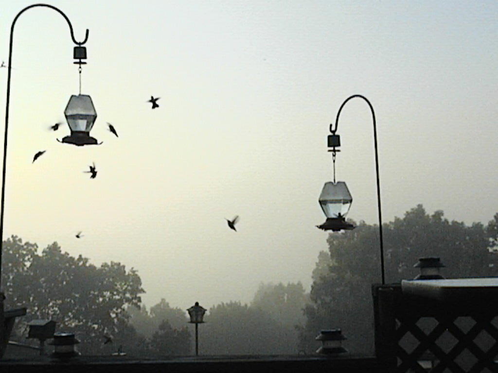
Steve Felts our Channel 3 Skywatcher from Murphy, NC and I are kindred spirits. Both of us share a love of the natural world, weather and photography. And now I find we both like hummingbirds. This picture is his work. A whole fleet of hummers swarming one of his feeders. (To see more of his photography check out Steve's Blog: http://lovinmountains.blogspot.com )
I have to admit the hummingbirds around my house have had to look elsewhere this summer. My feeders stayed in the garage this year, and I can't explain why. But Steve's picture has prodded me into action. This weekend I'll go out in the garage, clean out the feeders, and fill them. The nectar is still in the kitchen cupboard.
Many people think you shouldn't leave your feeders up all year. They fear the hummingbirds will be convinced to stay around and may freeze to death. But according to the Georgia Department of Natural Resources, that's a myth. They migrate according to daylight length not food sources. Most of them leave the area in early to mid October. But a number of them do winter in the area. I have had reports in the past from Ellijay of hummers staying there all year. Georgia DNR says 100 confirmed Rufus Hummingbirds wintered in the state last year.
As we gradually watch these creatures leave others will be moving through.
The Tennessee Wildlife Resources Agency says the Monarch butterflies began moving through the state on Sept. 4th. (I saw a few Labor Day weekend in Southern Illinois and Kentucky. But I haven't seen any here yet, although you might have.) TWRA also says we'll begin to see Teal and Ospreys moving through any day now.
While I'm out in the garage getting the feeders I'll check up near the vent on the front of the garage. That's where the most reliable migration is yet to take place.
Some of you may have heard me talk about "Batman". Not the superhero. The bat that lives in the garage for several months every year.
I have several aneroid barometers in the house, some more accurate than others. I collect them because I like old weather instruments. But Batman is the most accurate instrument when it comes to gauging the seasons. Those first chilly days of Autumn are often followed by long spells of warm weather. Batman seems to know this and he'll hang out until just before it gets cold and stays cold. Then he's gone. Same is true in Spring. There are those first warm days that are often followed by bone chilling cold. But when it's warm for good, batman returns. And it's been that way for years. His accuracy is 100%. Of course his life depends on it.
Late last summer batman had a friend out there. The two were chattering at each other and crawling around the vent. I suspect it was batgirl. I'm not sure what happens to bat couples, but I was hoping there would be at least one more bat hanging around the garage. Because one Spring the warm days will return for good and batman won't. And I'll miss watching my little living barometer.

Thursday, September 08, 2005

Fair weather, Ophelia, Helping Pets

This has been an extended stretch of nice weather in The Tennessee Valley. If it weren't for a double-check on the calendar, I'd think it was October. Usually we don't enjoy dry air, cool mornings and warm afternoons until the 10th month. But we'll take this as long as it lasts. If my math is correct, we have had 38 days this year with highs 90 or above. In a normal year we have 46. The last time we officially hit 90 or higher was on Sept. 2nd when we made it to 91. So we have had 5 days without a 90 degree reading. A bit surprising considering the time of year and the fact we have had nearly full sun. The last time we went more than 5 days without hitting 90 was July 10th through the 17th. A rather rainy period with over 2.5" in Chattanooga.
Ophelia remains a bit of a mystery. Right now she appears to be gradually strenthening with 60 mph winds. This morning's problems are two-fold. First Ophelia is expected to become a hurricane in the next 24 hours. And the second problem is the storm is not moving much at all. In fact The National Hurricane Center has the system off the Florida Coast for the next 3 to 5 days. http://www.nhc.noaa.gov/refresh/graphics_at1+shtml/085310.shtml?5day?large
I think there's still potential for Ophelia to cross Florida and end up in some form in the Gulf. Most of the models like the idea of a turn out into the Atlantic. We'll see.
The Humane Society of the United States is asking web administrators and bloggers to add a link to their site. The outpouring of help for the human survivors of "Katrina" has been tremendous. Let's hope there's some help for the four-legged survivors as well.

If you would like to contribute, here's the link: http://www.hsus.org/


Wednesday, September 07, 2005

Environmental Flip - Flop

This picture of the Gulf Coast at sunset was sent in by Reta Voss. To me it's a reminder of how beautiful the region is, and why we value it as a natural resource. The ripple effect of Hurricane Katrina is going to be felt environmentally in the days ahead, which is a downturn from news released earlier this summer.
Let's begin with this past summer and the Midwest drought. Less rainfall meant less runoff. The resulting lower water volume carried with it less agricultural runoff and other chemicals. So back in July the National Oceanic and Atmospheric Administration issued a forecast for the Gulf "Dead Zone" saying it would be a lot smaller than the average size during the past 15 years. The "Dead Zone" is created when fertilizers cause algae to grow quickly. The algae then settles and decays consuming oxygen in the water, which kills other forms of aquatic life. According to NOAA, the area in the Gulf hardest hit over the past 15 years has been around 4,900 square miles. This year because of the drought it was diminished to around 1,400 square miles. That's still an area the size of Rhode Island.
And now the flip - flop.
Headlines around the world this morning are talking about the polluted water from New Orleans and where it's headed. There's no doubt that toxic water has to be pumped out of the city. And pumped out as quickly as possible. But there's no way it can be cleaned or filtered. So Katrina's final blow will be dealt to Lake Pontchartrain and the waters and beaches of the Gulf Coast. Billions of gallons of water contaminated by everything you can imagine all headed out and away from New Orleans. Many have described it as a toxic soup. NBC Nightly News had a sample tested and the results said the water had 45,000 times the bacteria level considered safe. 45,000.
I haven't heard if there will be any attempts to track this influx of pollution. But my guess is the "Dead Zone" which was coming back to life has been dealt a killing blow once again.
Today will be another very pleasant day here in the Tennessee Valley. And we'll continue to monitor Tropical Storm Ophelia. She promises to be another big forecasting headache for the National Hurricane Center.
http://www.nhc.noaa.gov/refresh/graphics_at1+shtml/084956.shtml?5day?large

Tuesday, September 06, 2005

NOAA Provides Hi-Res "Katrina" Images

This is one of the pictures offered by NOAA of the damage left behind by hurricane "Katrina". Nearly 3,000 pictures are now available online by following this link: http://www.noaanews.noaa.gov/stories2005/s2495.htm
You will be amazed at the quality of the pictures, and how much is devastated. But I also noticed some areas where homes appear unscathed.
It's great hearing how the Tennessee Valley continues to respond to this tragedy. Every day you see how residents here are helping evacuees. I wonder how many will become permanent residents after seeing how great Chattanooga is. Some 500,000 residents are seeking shelter in other places right now. How many of them will call those places home?
Right now those here are visiting the city when Mother Nature is at her best. Full sunshine and low humidity makes for 20 to 25 degree swings in temperatures. Yesterday we went from 64 to 87. This morning's lows were similar in Chattanooga. Here at Channel 3 we dropped to 62, but Athens, Dayton, Dalton, Ft. Payne, and Murphy were all in the 50s. The Murphy / Andrews airport had 54 this morning, so some spots near there were probably around 50. Not exactly teeth chattering, but if you left the window open over there last night you were probably grabbing a blanket this morning.
There are 16 days until Autumn begins.

Friday, September 02, 2005

Stunning Response From Everyone!!


(Talk 102.3 FM's Scott "Quake" McMahon and Wally Witkowski at the Hurricane Katrina Relief Drive) WOW! The Tennessee Valley has really pulled through for the survivors of Hurricane Katrina. Cars and trucks streamed into Velocity Sports for the relief effort starting a day early and kept on coming through last night. When the numbers were tallied, you helped raise over $133,000. And you brought in 13,000 cases of bottled water, enough to fill 7 semi-trailers.
Everyone who came had a story. Some were hurricane survivors from past storms. Others had friends or relatives in the effected areas. But overall it was just people, churches, and schools doing what they could. One man came up and said he didn't have much, but he wanted to give five dollars. And this wasn't the only successful drive being held in the area yesterday.
I know this won't replace people, homes, or belongings that were lost. But I believe this will replace some lost hope.
Right now people in New Orleans are asking, "Where is the help?" We know that. What THEY don't know is....it's here. And in communities across this great country of ours. Soon they will find out Americans are rallying behind them. And I believe many of them will be lifted up from their darkest hours by the shining generosity shown here in Chattanooga and elsewhere.
(The event was co-ordinated by Talk 102.3, KZ 106, The Duke FM, and Channel 3 Eyewitness News.)

Katrina Relief Part 2


Above - State troopers from Georgia and Tennessee along with Chattanooga police officers. They were promoting "Hands Across The Border" an annual safety reminder before the Labor Day weekend. And on the spot someone suggested taking up a collection. Their wallets opened up and they raised about $400 right then. Stories like that were told time and time again yesterday.

Katrina Relief Part 3


The water and money flowed in all day. And many of those who came by had other offerings. Some volunteered trucks, others labor, some brought other necessary items. One doctor's office brought by a big box of Tylenol samples. I imagine things like that will help a great deal. Above is Jeff McClain one of Channel 3's producers. I think Jeff was like so many who came by to drop something off, and ended up staying to lift and stack water.

Katrina Relief Part 4


These pictures were sent to me by Mr. Duke Stone who is the principal of Hamilton Heights Christain Academy. The students volunteered to help unload water and let me tell you, they were a big help. Thanks to a great bunch of students. Jed, LaTrice, and I had the best time working with you.

Thursday, September 01, 2005

Saying Thanks! - Part 3


Some of the attendees: (top) The Sewells from Red Bank, The Felts from Murphy, NC.
(bottom) Sandra Ross from Athens, The Stones from Mowbray Mountain.
To All of our skywatchers: Thank you for another great year of service!

Saying Thanks! - Part 2


More pictures from the Channel 3 Skywatcher BBQ. Thanks Duane Bryan and Don Foley for getting the BBQ details in order and making sure everyone had a great time!

Saying Thanks!


Every year we pick a day to say thanks to our skywatchers, and this past Friday was the day. Paul and I had a great time seeing everyone who provide not only accurate weather observations, but also many smiles along the way.
We are very fortunate to have these volunteers giving their time and talent virtually 24/7 365.
These pictures are from the skywatcher BBQ which was held at the Tennessee Riverpark. The evening was clear and comfortable. And the food was terrific.