Wednesday, May 24, 2006

Thoughts Turn To Fishin', Family And Friends

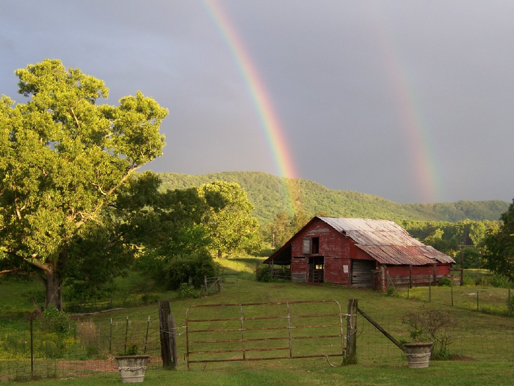
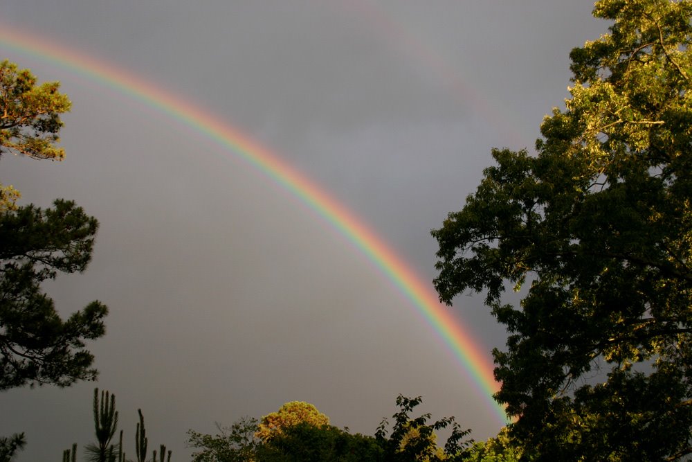
Thanks this morning to Mark (I wish I had a last name.) for sending this great picture of thunderstorm over Lake Chickamauga taken from Big Ridge. It's a beautiful picture, and if you click on the image to see the full-sized view it appears that there is a rainbow on the left.
This past weekend I saw quite a few boats and watercraft on the lake as I drove past the Harrison Bay area. I can only imagine how busy the lake will be this weekend as thoughts turn to fishin' and enjoying a day on the lake. (I'm whistling the Andy Griffith Show theme.)
Right now I think much of the holiday weekend looks good with steamy conditions and our first 90 degree day either Saturday or Sunday. Which would fall within the range of dates the first 90 was recorded in the last 10 years:
  • April 18, 2002
  • May 12, 2000
  • May 17, 2001
  • May 18, 1996
  • May 19, 1998
  • May 21, 2004
  • June 3, 1999
  • June 5, 2005
  • June 23, 1997
  • June 24, 2003

Today we'll see mostly sunny skies with highs in the city around 87.

Partly cloudy tonight with a slight chance for a shower or storm by daybreak. Lows will end up around 64.

Thursday and Friday: Scattered showers and storms, some could be strong to severe. Highs both days in the mid 80s.

Upper 80s to near 90 Saturday through Memorial Day. It will feel steamy with partly cloudy skies. And with heat and humidity around we'll have a slight chance for an isolated afternoon storm popping up.

See if you remember this ditty:

"From the lakes of Northern Canada, to the Gulf of Mexico......wherever fish are biting, that's where we're gonna go. There's a lot of exciting country......just waiting to be explored. So join us now in the great outdoors, The World of Virgil Ward."

One of my favorite shows as a kid. I was always amazed by the places Virgil would travel to and the different fish species highlighted each week. But one of my favorite parts of the show was when Virgil would show the various actions of lures in the aquarium in his studio.

According to bassinusa.com, Virgil passed away in 2004 at the age of 93. And he was fishing up until a couple of weeks before his death.

This weekend while I'm staring at a bobber, I'll think back on all the great shows he produced and all the people who probably ventured into the outdoors for the first time because of him.

I'll also think about my dad who introduced all of us kids to fishing and an appreciation for nature. (I think he was a Virgil Ward fan too.) And I'll think about my brother-in-law who was a great fishing, hunting, and camping buddy. There are other family members and friends I'll pause to remember this weekend as well. Fortunately, all with a tear in the corner of my eye and a smile on my face.

Happy Memorial Day to all!

Tuesday, May 23, 2006

More Hail Pics, First 90 Degree Day Ahead.


A few more hail shots for you this morning.
First thanks to Ricky Crews for the nice shot on top of the 2 1/4" hail that fell at his house in Cleveland, TN.
The middle picture was taken in Hopewell, TN near Cleveland. Thanks to Erin Earnest for that shot. Erin says the huge hail fell for a full 5 minutes!
And finally thanks to Keith Stalcup who lives in Eastern Bradley County. And that's 4 year old Novalee Stalcup holding one of the baseball sized chunks of hail that fell at their house.
There is a certain beauty to the close-ups of the hail. Click on the top photo for a full-sized view and you can appreciate the almost geode look to some of the stones. And the frozen- fused look of the small stones that clumped together and fell as one chunk of ice.
When I was in West Texas we used to have this kind of hail 3 or 4 days a year. Back then, one of my skywatchers was Chris Roach. Chris was a retired meteorologist from the National Weather Service, and had done upper air soundings for White Sands Missile Range. Chris knew weather, and always had valuable storm information. One storm was pummeling the Paint Rock, Texas area one June day with softball sized hail. This was before the national lightning dectection network was up and available to television stations. So when Chris called I wasn't surprised by what he had to say at first. "Thom I heard that storm coming before it got here." "I bet you did. That thing probably had a ton of lightning and thunder with it.", I replied. Chris said, "No sir. I heard the hail-stones drumming the ground as it was approaching." There was that much hail it was literally telegraphing it's approach by pounding out a rhythm on the hard Concho Valley ground.
No threat for storms with hail for the next two days though.
We'll see mostly sunny skies today and tomorrow, with temps jumping from the low 80s this afternoon to the upper 80s Friday afternoon.
Scattered storms could move in as early as Thursday morning. And then we'll have scattered storms both Thursday and Friday afternoons. Additional clouds and scattered storms should hold highs down a bit. Look for mid 80s both days.
Then for the Memorial Day weekend things look steamy with highs in the upper 80s to near 90. With summer heat and humidity, we'll have to keep a slight chance for an isolated afternoon storm or two in the forecast for the entire holiday weekend.
A lot of folks will be flocking to the lakes and campgrounds this weekend. And for the most part it looks like typical summer weather for all. Enjoy!

Monday, May 22, 2006

HUGE Hail On Saturday! Here Comes The Heat.


Many thanks to everyone who sent pictures in to the Channel 3 Storm Alert Team this weekend.
Thanks first to Dusty Strickland of Cleveland, TN for the top picture. He's a science teacher who used the storm as a quick science lesson for his children who are holding up the hailstones that were up to 3" in diameter!
The middle picture was sent in from Sale Creek, TN. Many thanks to Susan Iles for the nice shot of the golfball sized hail at her house. (You definitely needed to yell, "FORE!")
And finally hats off to David Goodwin for the third picture. You can tell he had lots of baseball sized hail in his yard in Cleveland.
This pesky front is still stalled across the area today, but is slightly to the north of Chattanooga. Showers and a few storms are along this boundary early this morning from Athens, TN right through the Bootheel of Missouri. So I think we'll continue to see storms firing along the front and drifting ESE towards us throughout the day and into tonight. Some once again could become strong to severe.
The front ends up to our south for Tuesday and Wednesday so we should end up dry both days. Highs on Tuesday from the low to mid 80s. Wednesday's highs should top out from the mid to upper 80s.
This see-saw front will end up back our way Thursday and Friday with increased odds for showers and storms both days. Highs will continue in the mid to upper 80s.
Then I think the rest of the Memorial Day weekend will be dry, but steamy across the area. Highs will likely end up between 85 and 89 each day Saturday through Monday.
The only real question for weather geeks like me is, "When will we officially hit 90 for the first time at Lovell Field in Chattanooga?"
This past Saturday we hit 87. We were hotter only one other time this year, on April 17th we topped out at 88. So I'll throw a dart at the first 90 and say we hit it on Saturday.
At any rate the ice companies are probably getting ready to work O.T., to cover demand for the upcoming holiday weekend.

Friday, May 19, 2006

Good Old Summertime Ahead


It was "Photo Friday" this morning on Channel 3 Eyewitness News Today and we had two beauties to show off.
First thanks to Freida and Mike Morgan of LaFayette, GA for the top rainbow picture taken at their farm.
And thanks also to Cain Smith who's a sophmore at Trion High School. He snapped the vivid colors in the second picture above. (By the way, Cain's mom is a professional photographer who has a lot of beautiful pictures on her website: http://rachelpennington.com . )
Great job and thanks again everyone! Keep those pictures coming.
A nice cool start to the day today. The Murphy - Andrews airport has so far dropped to 37 this morning. With Dayton, Athens, and Ft. Payne slipping to a chilly 41. And we are really getting a treat with some high cirrus clouds color-izing the sunrise today.
A nice day for most of the day today. But there's a system in the Midwest this morning that will drop our way and increase our rainfall chances from late this afternoon into tonight. There is some potential for strong to severe storms. Highs this afternoon popping up to around 78.
The weekend looks quiet overall with highs into the low 80s both days. But with this weak front still lingering in our area, I don't think we can totally rule out a daytime storm popping up either day. But that chance is only 20% both days.
Early next week we go into the mid 80s with a summertime chance for an isolated afternoon storm popping up.
A lot going on across the area this weekend. Antique alley along highway 11, River Roast 2006 at Ross's Landing today and tomorrow. And the Pat Boone Bethel Golf Tournament at Bear Trace. I'm looking forward to losing a few golf balls around and probably IN Harrison Bay this weekend.
I hope you have a great weekend!

Thursday, May 18, 2006

Storms Boom Then Heat Blooms

These purple flowers burst into full bloom a couple of weeks ago in the front yard and were fantastic. Had I known how nice this bush would grow and put on such a showy display, I would have bought at least one more of them.
This morning some showers are moving across Middle Tennessee and should zip through here in fairly quick fashion. This front will also usher in some windy conditions this afternoon. Look for winds to swing around to the northwest and increase to 15 to 25 mph and gusty this afternoon. I think we'll see highs today around 74.
Fair and cool tonight with lows around 51.
Partly cloudy with some scattered storms Friday afternoon. Some storms could be strong to possibly severe Friday afternoon across the region. Highs around 76.
Then things start to heat up. Only a slight chance for an isolated afternoon storm on Saturday with highs around 82.
Sunday - Partly cloudy 83.
Monday - Partly cloudy 85.
Friday marks the first day average the average high is 80. So today and tomorrow still look to end up below normal. And it's yet to be seen how hot things can get next week. One computer model is suggesting these numbers for highs:
  • Sun - 87
  • Mon - 88
  • Tue - 86
  • Wed - 88
  • Thu - 84

I don't think we get that hot, but it certainly tells us that heat will be blooming here late in the weekend and into next week.

Wednesday, May 17, 2006

Easing Into Summer Temps - 200th Post

It's the odometer syndrome again. I'm one of those who watches the "big" miles turn over, so I suppose this is a milepost of sorts. This is the 200th post on Fishyweather. Thanks Jeff for getting me started.
I mowed the lawn yesterday in a sweatshirt while the temp at the house was only 57. ("How many times will this happen in mid May?", I thought to myself.) I think lawn services will be going bananas trying to keep up with mowing over the next two weeks as the moisture in the ground and warmer, sunnier weather takes over.
Pretty foggy in some areas early this morning with visibilities down to less than 1/4 mile in some cases. But once that burns off we'll have partly cloudy skies this afternoon with highs in the lower 70s. We'll still have a slight chance for a spotty storm this afternoon.
Thursday should be a tad warmer with partly cloudy skies and a slight risk of an afternoon storm. Highs on Thursday around 76.
Friday looks like a toss-up. One model has a batch of showers and storms swinging through early Friday morning into early afternoon. Another model says a slight chance with lower rainfall amounts. We'll see how this looks tomorrow morning, but right now I'm going with the idea that skies will be partly cloudy with a few storms popping mainly during the afternoon and evening. Highs on Friday should top out around 77.
Saturday and Sunday look partly cloudy with slight chances each afternoon. Highs both days in the upper 70s to low 80s.
Long range looks interesting in several areas. First beastly heat may develop from West Texas into the Four Corners starting Sunday and lasting into the middle of next week. So of this heat heads our way, and that's why I think it's possible to end up in the mid 80s the middle of next week. This seems reasonable from a climate standpoint as our average highs by then are around 81. So we could end up 3 or 4 degrees above average rather than 10 to 15 degrees below average.
And lately the GFS model has been hooked on the idea something suspiciously tropical develops in the Gulf and heads towards the Florida Panhandle and Central Gulf Coast. The last three runs have picked up on this feature which arrives down there Monday the 29th, and sticks around the Deep South through Friday, June 2nd. This blob of rain may turn out to be a blip in the model and never happen, but Gulf waters are warm and a low could form even if it never becomes a depression or named system. It will be interesting to watch to see if the GFS is sniffing out something real or not.

Tuesday, May 16, 2006

Warmer, But Still Below Normal Through The Weekend

This bush in the backyard doesn't have these blooms anymore, so I'm glad I captured them digitally while they were at their peak. We really have had a beautiful Spring this year.
The weather hasn't been ugly, but it would be nice to see some more sunshine. And I think that will come tomorrow and Thursday.
Today: Mostly cloudy skies with spotty showers popping up and moving across the area throughout the day. Highs only around 68 this afternoon.
Wednesday: More sunshine, but still a slight chance for a spotty shower during the afternoon hours. Highs will climb to around 72.
Thursday: Partly cloudy and warmer with highs around 78. We can't rule out an afternoon shower, but I think 20% should cover anything that pops up.
Friday and Saturday a weak front will hang around the area keeping a slight chance for a shower or storm in the forecast. Highs will stay in the upper 70s to around 80.
As of this morning we have had 11 days in a row with below normal temperatures. And even though we'll be warmer in the days ahead, our average climbs too. So we could have 16 days in a row with below normal temperatures by this weekend. However, it looks like a pattern flip may be in the works. The Climate Prediction Center now has the Tennessee Valley in the Above Normal temperature forecast for the period May 23rd through the 29th. And the way the models look this morning it would not surprise me to see highs into the mid 80s by the middle of next week. We'll see.

Monday, May 15, 2006

Hail Storms Again Saturday, Gradual Warming Ahead.


Special thanks this morning to Lisa Watkins of LaFayette, GA for sending in the top picture of Saturday night's storms. Thanks also to Gerald Wilson of East Ridge, TN for sending in the second picture of the hail at his house. And finally, thanks to Richard Williams of Chattanooga for sending in the 3rd picture in this post. All of these were taken on Saturday night.
Spotty showers will be possible the next three afternoons as the huge low north of us continues to swirl some clouds and cool air our way. But average amounts will be rather light, most areas seeing less than 1/4" over the next 3 days combined.
Highs today around 67. Near 70 tomorrow afternoon. Lower 70s on Wednesday.
Then warmer Thursday with highs near 77 with partly cloudy skies. Only a slight chance for an isolated shower on Friday with highs close to 80.
I'm not sure if it's a reflection of the gas prices, but this past weekend traffic on the interstate seemed a bit light for Mother's Day. But maybe they were still visiting when I was on the road.

Friday, May 12, 2006

Cool And Breezy Mother's Day Weekend, Showery At Times

I really love this shot. From a photography standpoint it's not that special. I could have framed it a little better, and maybe moved in a little closer. But when you look at the markings and the color of the butterfly, it's amazing to me. Click on the image above to see it full-sized.
Today will be partly cloudy, cool and breezy with highs near 70.
Tonight will be fair and chilly with lows around 46.
Saturday will end up a bit warmer as our breeze comes at us from the southwest, pushing our highs into the mid 70s. We can't rule out a spotty shower Saturday afternoon, but there shouldn't be much on the radar.
Saturday night some scattered showers and a rumble or two of thunder moves through but amounts will be 1/4" or less. This front will shift winds around to the northwest, so Sunday will be chilly again.
Mother's Day will be on the cool side with highs in the mid 60s. With northwest winds at 10 to 20 mph that's going to feel awfully raw at times. And there's still a risk for a spotty shower or two Sunday afternoon.
Shower chances continue Monday and Tuesday with highs in the mid 60s Monday, and into the lower 70s Tuesday.
Have a great weekend!

Thursday, May 11, 2006

Wild West Winds Today, Cold Air Round-Up Ahead.

I thought this picture turned out well. Click on it to see it full-sized and you'll see the butterfly's "straw" as this little fella is sucking the nectar out of the dandelion.
It has been absolutely amazing that three more times in just the last 24 hours we saw strong to severe storms approach, and weaken to some nice showers. I've said it before, (but considering what other parts of Tennessee, Georgia, and Alabama have gone through this season) it should be said again......we have been VERY fortunate with this Spring's weather.
The upcoming pattern isn't the best, but it's not ugly by any means.
Today we'll see west winds cranking up across the area. Look for sustained winds 15 to 25 mph with gusts at times to 30. With cold air aloft and some peeks of sun, instability showers could pop up just about anywhere this afternoon. And if any thunderstorms get going with this set-up look for more hailers. Showers dwindle tonight with lows in the upper 40s.
Friday looks like the best day in the next 5 days. Look for partly cloudy skies with breezy west winds 15 to 20 mph and highs near 70.
Saturday we'll see some spotty showers mainly during the afternoon hours with highs in the lower 70s.
Sunday another front blows through with scattered showers. But here's the kicker: highs Sunday afternoon will only be in the upper 50s to lower 60s. And lows will be in the low to mid 40s Monday morning.
Monday afternoon we could still see scattered showers at times with highs only in the upper 60s.
Here's how far off target temps will be the next several days:
  • Fri Sat Sun Mon Tue
  • 78 78 79 79 79 - Average Highs
  • 70 72 63 67 70 - Forecast Highs

Wednesday, May 10, 2006

What's Shakin' In Monroe County, TN?

According to the U.S. Geological Survey a magnitude 3.2 earthquake occurred this morning at 8:17 am EDT. It was centered in Monroe County, TN 1.82 miles Northwest of Sequoyah Estates. A 3.2 might have been felt or heard by residents there, but so far no one has called to say they felt anything unusual.

Prolonged Period Without Heavy AC Use Ahead?

These butterflies were not bothered a bit by the electronic shutter sounds of digital cameras the other day. I was not the only one trying to capture the striking colors. Sandie's niece is turning into quite a talented photographer, and it was fun to compare pictures later in the day.
Early morning thunderstorms have been flying in from the west, but losing some of their punch as they head east. If you were watching Paul Barys yesterday afternoon, you saw a similar thing happening then. A lot of lightning across western Tennessee down into Mississippi, weakening as they ran into more stable air here. So rain and storms this morning should keep things from getting very stormy here when the next round arrives this evening and tonight. Certainly frequent lightning, some wind and hail possible, but the worst of this stays west of us.
Two more large thunderstorm complexes are behind the first. One over Arkansas, the other in central Oklahoma. And in the driver's seat is a large upper low over Minnesota which will be the long term weather maker to watch. Looks like it will cut-off from the main flow and spin it's heels around the Great Lakes for several days. So a northwest flow aloft will take over heading into the weekend.
Right now it looks like showers end fairly early tomorrow morning and it turns windy tomorrow afternoon. Highs Thursday afternoon will top out around 73.
Chilly Friday morning with lows in the upper 40s. Partly cloudy and breezy Friday afternoon with highs around 72.
The weekend time frame has to include some slight shower chances both days. I think with northwest flow above the ground, chilly air aloft and any small scale disturbances we could trigger a late morning or afternoon shower either day. But it looks like Mother's Day there would be a better chance for a few more of these showers popping up.
An eastern trough in the jet is favored in the pattern for the next two weeks. And while it looks like things get warm around the 20th, the Climate Prediction Center keeps most of the U.S. east of the Mississippi River cooler than average through May 23rd. Wow if that pans out! Could a prolonged period without heavy air conditioning be in the cards?

Tuesday, May 09, 2006

Fluttering Back And Forth From Warm To Cool.

I have several shots of different butterflies on this lilac bush. And considering this plant is only about 3 feet tall and about 3 feet around, it's amazing how much drawing power these tiny flowers have. Seems like bees and butterflies are constantly swarming this feeding station while it's in bloom. So I'll post quite a few, as these little critters were very co-operative with this over sized shutter-bug.
We have been fluttering back and forth from warm to cool the last couple of weeks. That tidbit wouldn't raise that many eyebrows considering it is Spring, but when you look at where we've been it's interesting.
For example let's look at daytime highs in Chattanooga compared to average:
  • In March 18 days above normal, 13 days below
  • In April 25 days above normal, 5 days below
  • In May 3 days above normal, 5 days below

What makes this interesting to me is the turn-around that appears to be shaping up in May compared to April. I know it's still early, but it appears that an eastern U.S. trough may keep temps a bit cooler than average for the next couple of weeks. Not to the extreme that temps were above average in April, but cooler than average by 5 degrees or so. We'll still have some warmer than normal days stuck in there, but I think it will be interesting to see the May numbers at the end of the month.

Short term: We have a lot of low clouds across the area this morning which will begin to break up this afternoon. We're warmer this morning, so I think we'll end up around 78 today with just a 20% for an isolated storm popping up. Mostly cloudy tonight with a slim chance for a shower or storm overnight. Look for lows by daybreak around 63.

Wednesday: Showers and storms mainly from afternoon into the nighttime hours. There is some potential for a few strong to severe storms, but no big outbreak expected. Rainfall should end fairly early Thursday morning with average amounts between 3/4" to 1".

Thursday: Decreasing clouds throughout the day, breezy and a bit cooler with highs in the low to mid 70s.

Friday and Saturday: Partly Cloudy skies with morning lows in the upper 40s, and daytime highs in the lower 70s. (Again with partly cloudy conditions, those highs are a tad cool for the time of year.)

After that model mayhem rules, but troughiness seems to stay in the east. We'll see.

Monday, May 08, 2006

Thankful For What We Don't Have.

While on a walk in the woods or a dive along the bottom, I can sometimes overlook the small things while scanning the overall scene for the big stuff. Before I took this picture, I was marveling at the tulip poplars, the red buds, and the dogwoods. When right at my feet the violets were putting on a pretty nice display on a different scale.
And so it is with weather forecasting. You always have to search for the little weather features while examining the big picture.
This morning I'm reminded that we are thankful for what we don't have and that's flooding. On this date 3 years ago we had ongoing coverage of historic flooding across the Tennessee Valley. The rain was stopping on May 8th, 2003, but not before inundating some locations with 10" to 15". Here's a look back at what fell at Lovell Field in Chattanooga:
  • May 5th 2.45"
  • May 6th 3.28"
  • May 7th 1.60"
  • May 8th .02"
  • Total 7.35"

As of this morning we are:

  • + .03" for May
  • -2.52" Since March 1st
  • -5.53" Since January 1st

But these numbers aren't really that meaningful as long as we continue to have 1/2" to 1" on average, every week to 10 days during the growing season. As long as we can keep that kind of pace, lawns and gardens will be fine. At this point you really don't want to make up a paper drought of 5". That could put us back into a 2003 situation. (Dry spells build up over time, but they are rarely reversed that gradually.)

So what's ahead? Morning fog burns off and this afternoon we'll go partly cloudy with highs near 76. Patchy fog is once again possible Tuesday morning. And much of the day on Tuesday will be dry. If you look at the small stuff, you'll see a slim chance for an afternoon shower tomorrow, but I think significant rain won't show up until Tuesday night and Wednesday. Then I think this system will pull out leaving Thursday afternoon through Saturday dry. Another system stirs up some showers on Mother's Day as it dives down on us from the northwest.

This week's rainfall quota could be met Tuesday night through early Thursday with 3/4" to 1" on average across the area.

Friday, May 05, 2006

Wet Today With A Split Weekend Ahead.


A quick story about this picture. This red bud tree is in my father-in-laws yard. And it is really a big, full, and beautiful tree. But it wasn't always that way. When he planted it, the tree was doing well for a few years. Then it died back. My father-in-law was going to cut it off at the ground and get rid of it. But before that happened, Spring rolled around again and the dead sticks began showing signs of life again. And every Spring since then it's been putting on an amazing display of purple. I'm not sure if this is common among red buds, but the one I transplanted from his yard into mine did the same thing this year. I have two red buds in the yard, and the bigger of the two appeared to be dead this year. But Dick said, "Don't dig it up yet, look what happened to mine." And sure enough, right now there is new growth near the bottom of what appears to be a small dead tree. So I'm hopeful this turns out to be a great looking tree with time. We'll see. (When I think about these two trees, the story feels more like a Sunday school lesson than a gardening tip. Don't give up hope, even when the odds are long and sometimes the rewards can be remarkable and long lasting.)
Big area of light to moderate rain early this morning across Middle Tennessee sliding towards us. This will move in late morning to early afternoon. Then I think we'll see a few breaks in the clouds late this afternoon with a few scattered storms popping up.
Saturday we'll start off seeing foggy areas, but the rest of the day look pleasant. Look for partly cloudy skies with highs in the upper 70s to near 80.
Sunday will be another story. Another round of rain and storms moves through mainly from Sunday afternoon through Sunday evening. And right now it appears there may be more rain on Sunday than today. But totals from today through Sunday night will likely add up to 1" to 1 1/2" across the area.
A slight chance for a few afternoon storms Monday afternoon with highs in the mid 70s.
Dry and warmer Tuesday with highs near 80.

Thursday, May 04, 2006

Soaking Rains Ahead, But Weekend Dry Gaps Likely.

Scattered showers and storms will develop today and again tomorrow. In fact it looks like the afternoon and evening hours will be busy area-wide the next two days with some potential for strong to severe storms.
But right now the models seem to agree on a dry spell from late Friday night through Saturday afternoon. Saturday night and early Sunday another round of showers and storms should move through, but even this may get out of here Sunday afternoon.
Highs will be near 80 today.
Upper 70s Friday.
Mid 70s Saturday.
Temperatures should cool to aroun 70 for a high on Sunday.
Monday will be partly cloudy with highs in the low to mid 70s.
Average rainfall amounts from today through Sunday should tally up to 1.25"+ to 2"+.
Fortunately I got the lawn knocked back some yesterday afternoon. And parts of the yard were still pretty wet from Tuesday night's thunderstorms. And the way things look it will stay soggy for several days.

Wednesday, May 03, 2006

Dry Today, Then Bottom Falls Out?


Thanks this morning to Tom Hesler of Isabella, TN for sending these pictures in last evening of the hail in his yard. Tom said this happened around 8 pm, and stayed on the ground until after 11 pm. Some of it was quarter-sized.
A bit of a breather today for Dudley. He was frantic for awhile yesterday afternoon. And again after midnight for a few hours as the storms rumbled across the area. Several others here had animals in the same condition. We have some chill pills from the vet, but with afternoon storms that move through in 30 or 40 minutes I really hate to do that to him.
After a foggy start this morning we'll have partly cloudy skies with afternoon temperatures into the low 80s.
Patchy fog redevelops tonight with lows around 60.
Then our next front pushes into the region and stalls Thursday through Saturday night. I think we're looking with several rounds of rain and storms. By the time it all wraps up, average rainfall amounts may end up between 2" and 3". Over 3 days time, that's probably not much of a problem. But we will have a few strong to severe storms during that time frame.
It looks like we'll dry out late Saturday night through Sunday.

Tuesday, May 02, 2006

Rounds Of Storms Ahead, Then Cooler.

Today's picture was taken in Southern Illinois while the dogwoods were at their peak. The woods earlier were full of the yellow jonquils flowing down through the valleys. And then pockets of snowy white appeared. Gardening Guru Tim Holcomb says you can thank wet weather late last Summer for the spectacular Spring floral display we're enjoying this year.
We're waking up to a spectacular sunrise this morning with comfortable temperatures between 45 and 50 in most spots.
There are several clusters of storms moving across the U.S. early this morning. One across Kentucky, another in Arkansas, and the third over North Central Texas. There is a trough stirring these storms up that will be easing it's way into "our neck of the woods" this afternoon helping to spread some storminess our way. And a few storms may become strong to severe through early evening.
Then we'll have a dry day tomorrow with highs into the low to mid 80s.
This little heat bubble will get burst with another front dropping into the Tennessee Valley Thursday. This boundary will get stuck here through at least early Saturday keeping rounds of thunderstorms possible from Thursday through early Saturday. Then cooler and drier air will take over for Saturday afternoon and Sunday. I still think that after highs near 80 on Thursday, we'll drop to around 76 on Friday, and near 70 on Saturday. And maybe upper 60s to lower 70s on Sunday.
This kind of pattern is the "make hay while you can" kind of weather. Tough to get a string of dry days put together. So if you work outside and need more than two dry days in a row, you may have to wait until late in the weekend into the first part of next week.

Monday, May 01, 2006

Chilly Air Retreats, Then Repeats.

Wow! What a blustery day yesterday, and the scattered light showers didn't help matters much. This colder air will be retreating the next few days, but it appears another dip in the jetstream rolls over us by late Saturday and into Sunday. This time around it may not be as cold, but it looks like below average temps move back in late in the weekend and early next week.
Inbetween we'll see warmer weather beginning today with highs into the lower 70s. One weak wave moving out of Arkansas this morning may trigger a spotty light shower or two this afternoon. And a slight chance for a spotty shower hangs on tonight.

Tuesday we should see scattered showers and a few storms as the first of two fronts this week sags into the area. Look for highs in the mid to upper 70s Tuesday afternoon.

Wednesday will be partly cloudy and warmer with highs into the low 80s as the next front gets ready to head our way for Thursday and Friday.

Thursday and Friday look for scattered showers and storms, especially Friday afternoon and evening. Highs near 80 on Thursday, mid 70s Friday afternoon.

Saturday has a showery look to the first half of the day. And right now Sunday and Monday look dry but cooler. The chill might not be as sharp as this past weekend, but we should see highs below average by 8 to 10 degrees. That would put us in the mid to upper 60s across the area on Sunday, and maybe upper 60s to around 70 Monday.

May by the numbers:
  • Average Temps: May 1st 76 / 51
  • May 31st 83 / 61
  • Record Temps: 99 5-29-1941
  • 34 5 - 4-1971
  • Average Rainfall: 4.28"
  • Wettest May: 12.00" 1929
  • Driest May: .54" 1941

According to the Climate Prediction Center May will be close to average in both temperature and rainfall here in the Tennessee Valley. We'll see.