Cool Tropical Shot, Shot Of Cool For Us.
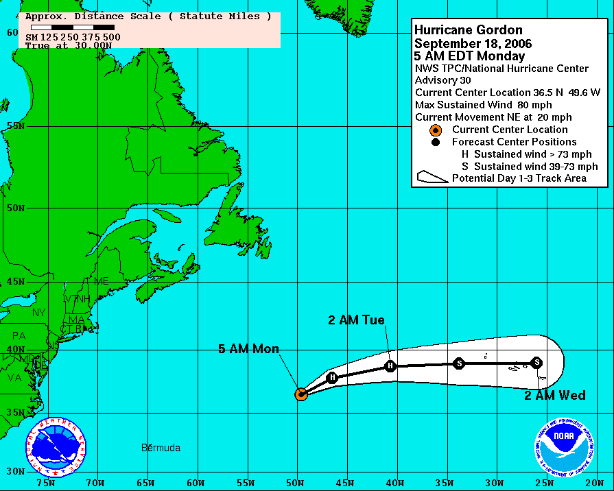

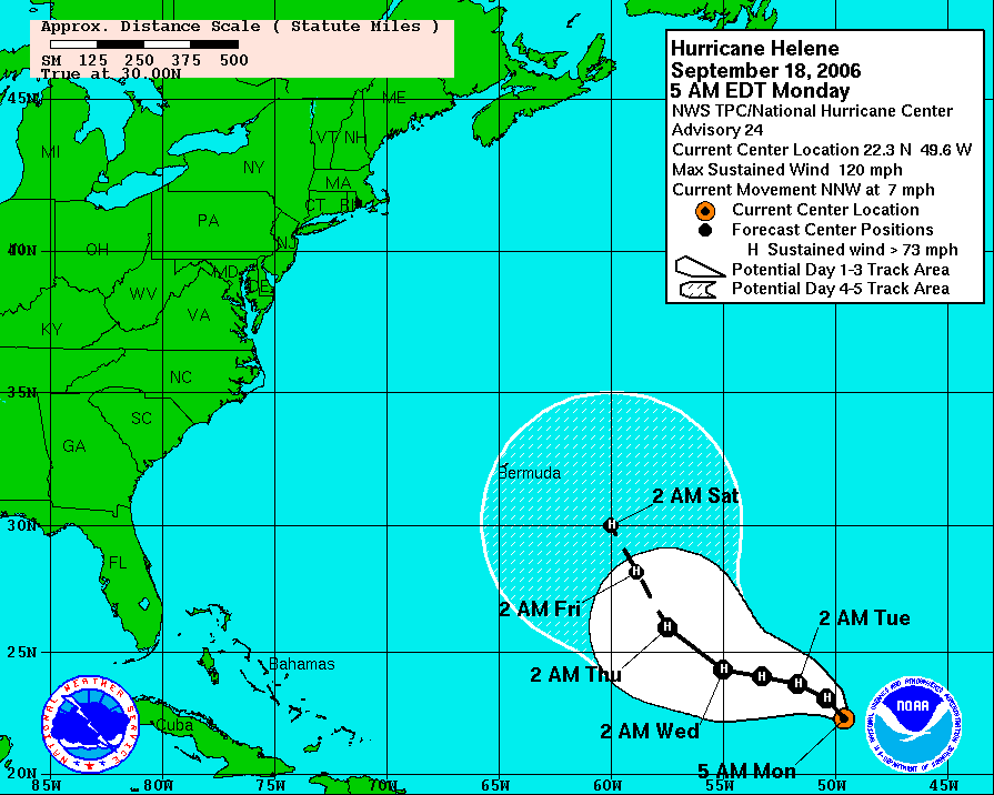 Check out the Atlantic satellite picture with hurricanes Gordon and Helene just about vertically stacked along 49W. Both systems still churning away, and turning away from the U.S.. Also notice the little system spinning up just east of North Carolina's outer banks.
We're focused on a front that will bring us rain and a few thunderstorms from late this afternoon through early tonight. Ahead of this we'll see some sunshine through the clouds early this morning. As the rain and storms arrive, most areas should see 1/2" to 3/4" of rain by early Tuesday morning. Tuesday afternoon will turn cooler and breezy as skies become partly cloudy. Some real Autumn chill Wednesday morning and Thursday morning. A lot of outlying areas will be in the 40s!
By the way, the question those temperatures will evoke is; "When does Fall officially begin?" But the answer is a bit of a trick question this year. In Chattanooga, it's Saturday. But in Jasper, TN it's Friday. What????? That's right because this year Fall officially begins at 12:03 am EDT Saturday. So in the central time zone, that's 11:03 pm CDT Friday.
Here's the scoop on the next few days:
Today: After some morning sun, clouds thicken this afternoon with showers and a few storms moving in. High: 82
Tonight: Showers and a few storms, especially early tonight. Low: 65
Tuesday: Early morning showers especially southeast of Chattanooga. Then some clearing, breezy and cooler. High: 76
Wednesday: Chilly morning with lows in Chattanooga around 53, then sunny and pleasant Wednesday afternoon. High: 73
Thursday: Wake up temperatures in the 40s for most areas. In the city near 50. Mostly sunny Thursday afternoon with highs around 76.
Friday: Partly cloudy with a chance for showers and storms as we head toward Friday night. High: 78
By the way, we hit 89 in Chattanooga Sunday afternoon and with two front rushing through here in the next 7 days it makes me think an official 90 may not happen again in 2006. That's not rock solid with above normal temperatures possible by the end of the month. But by that time our average high is 78. Historically we have not had a 90 reading in the city after Oct. 9th. Although 89 was achieved on Oct. 21st, 1963.
posted by UnderH2Owxguy at 6:23 AM
![]()

0 Comments:
Post a Comment
<< Home