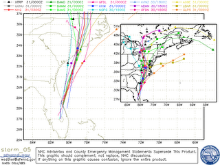
Ernesto Set To Soak Mid-Atlantic, We're Drying Out


 More than 12" of rain could fall over parts of the Mid-Atlantic states as Ernesto heads north. This morning the storm has 50 mph sustained winds, and with 18+ hours over the warm waters of the Atlantic, this could be a minimal hurricane by the next landfall near Charleston, SC. Whether or not it gets that strong isn't as important as the slug of moisture heading that way.
Our weather will be wettest east of I-75 today where some locations have seen around an inch during the overnight hours. Another inch of rain is possible in the Blue Ridge Mountains. But drier air is clearing the skies from Nashville to Memphis right now, and that drier air is heading for us. So enjoy a pretty nice Labor Day weekend in the Tennessee Valley.
Today: Scattered showers and a few storms. Heaviest rainfall east of I-75. High:85
Tonight: Showers mainly east of the city. Mostly cloudy overnight with a low of 69.
Friday: Partly cloudy with only a 20% chance for a pop-up shower. High: 84
Saturday: Partly cloudy with a 20% chance for a pop-up shower. High: 80
Sunday: Mostly sunny and less humid. High: 83
Monday: Mostly sunny and comfortable. High: 85

0 Comments:
Post a Comment
<< Home