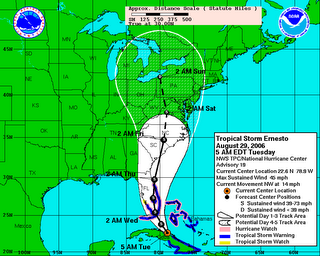
Where Will Ernesto's Moisture End Up?


 This morning marks the one year anniversary of the landfall of Hurricane "Katrina", which will be one of those "Where were you?" events in our lives. I hope there are not many more in my lifetime. Looking back at the final report some people forget that this was a double landfalling hurricane like "Andrew". And "Katrina" was deadly as a Category 1 storm in Florida. Here are some of the storm stats:
- Florida landfall on August 25th, 2005 as a Category 1 with 80 mph winds.
- Louisiana landfall on August 29th, 2005 as a Category 3 with 121 mph winds.
- Maximum intensity on August 28th as a Category 5 with incredible 167 mph winds.
- At the time, the central pressure of 902 mb was the 4th lowest recorded in the Atlantic basin. "Rita" and "Wilma" would eventually push "Katrina" down the list to 6th lowest.
- Maximum storm surge was 24 to 28 feet in Mississippi over an area 20 miles wide.
- An estimated 1833 fatalities, directly or indirectly from the storm. Which makes "Katrina" 4th or 5th deadliest in U.S. history.
- $81 Billion estimated damages insured, and uninsured. Making "Katrina" the costliest hurricane in U.S. history. Double the destruction of "Andrew" even when inflation is factored in.
"Ernesto" is the only tropical system close to home right now, and it is a 45 mph tropical storm this morning. There are two possibilities for this storm to become a hurricane. 1) Before landfall in Florida. 2) Over the Gulf Stream off the coast of Georgia or the Carolinas. The official intensity from the National Hurricane Center would take "Ernesto" into south Florida as a strong tropical storm nearing hurricane strength. So it's not out of the question a category 1 hits there. And this storm could re-intensify once it moves out over water in the Atlantic.
This storm has been trending east from day one, and I wouldn't be surprised if the path is on the eastern side of the forecast "cone" by days three through five. The farther east, the less rain we'll see. And that could pave the way for a very pleasant Labor Day weekend here. So we will be tracking this storm closely into the weekend here in the Channel 3 Storm Alert Center.
Today: Enough sunshine to push highs into the upper 80s this afternoon. Showers and storms become numerous this afternoon.
Tonight: Cloudy with occasional showers. Low: 73
Wednesday: Mainly cloudy with scattered showers and storms. High: 86
Thursday: Partly cloudy with 30% for storms, mainly east of the city. High: 85
Friday: Partly cloudy with 20% for storms, mainly east of I-75. High: 84
Saturday: Partly cloudy. (And less humid?) High: 85

0 Comments:
Post a Comment
<< Home