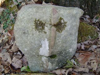
Who Dat? Rocky Face?

 Top picture is the friendly face I have been mentioning in previous posts that I found along the trail at Savage Gulf State Park. (Please tell me you can see the face. It's like the "Face On Mars". )
Bottom picture is thanks to Casey Alexander of Rossville, GA. Those were the nuggets that fell yesterday afternoon.
Lots of storms very early this morning, that as of 11 am are moving out of the area. Breaks in the clouds are seen on the visible satellite images across southern middle and western Tennessee, northern Alabama, and northern Mississippi. So it looks like we'll get some sunshine this afternoon to push highs into the mid and upper 70s perhaps. A thunderstorm complex is moving across Louisiana right now as well. Sometimes big complexes of storms like that can slow re-development in our neck of the woods. I still think though another round of strong to severe storms is possible from late this afternoon through early Saturday morning. Much of the area is soaked so it won't take much to have some localized flood problems before morning.
We'll start to dry out northwest to southeast across the area beginning tomorrow morning. When the sunshine returns Saturday afternoon the northwest winds will crank up at 15 to 20 mph and gusty making for a cool and windy day. Sunday looks fine for most of us, but there's a slight chance for a shower the closer you are to I-40 Sunday afternoon. Dry Monday, with some more storms possible Tuesday afternoon.
Have a great weekend!

0 Comments:
Post a Comment
<< Home