Awesome Pictures From Niota!
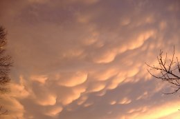
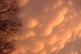
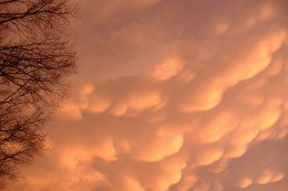

Wes Foster gets top honors today for his awesome weather shots. Wes took these back in December as storms were moving through the Niota area. I have always loved pictures featuring mammatus clouds. I have one on the wall near my computer that a friend of mine took in Southern Indiana years ago. And somewhere at home I have at least 2 boxes of other mammatus displays I never got around to getting in frames. I pull them out once in awhile and say wow. Just because I think they are the most stunning cloud formations in the world. (Standing lenticulars are a close second.) A very good site with more awesome pictures and descriptions is available at:http://ww2010.atmos.uiuc.edu/(Gh)/guides/mtr/cld/cldtyp/oth/mm.rxml
Yesterday's post featured a look at daytime highs for January. Today take a look at the comparison between December and January. December's average monthly temperature was 3.4 degrees below normal. January 2006 may end up as one of the warmest on record.
Here's a side by side comparison of daytime highs:
December January
- 60s: 2 Days 10 Days
- 50s: 10Days 12 Days
- 40s: 19Days 1 Day
- 30s: 0 Days 2 Days
To me the most striking numbers are the days in January in the 60s compared to December. And the number of days in December when the highs stayed in the 40s compared to January. These seem even more impressive when you consider that 23 days in December were recorded as either clear or partly cloudy. In other words even with sunshine or partial sunshine the mercury struggled to get up to the 40s and 50s, where we had MORNING LOWS 8 times this month.
I think we'll end up seeing highs above average for the rest of the month which probably seems like no big surprise. With sunshine today we'll make it up to 53. 56 Friday afternoon with mostly sunny skies. Clouds will increase quickly Saturday with highs in the upper 50s. Rain moves in Saturday night and Sunday. Right now it looks like most areas will average around 1 inch of rain.
The models seem to be wavering as to what happens in February. But right now it would appear that the excessive warmth of January will at least be trimmed back if not reversed in a big way. It will be interesting to wait and see.
posted by UnderH2Owxguy at 8:07 AM
![]()

0 Comments:
Post a Comment
<< Home