Encore Performance Ahead???

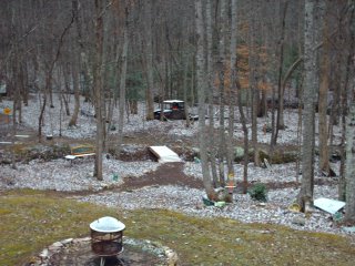
 Last week all four seasons, wrapping up Friday night and early Saturday as some snow showers and snow flurries for the mountains in the area. So a big thank you to everyone who sent pictures in to Channel 3 over the weekend. The first picture on top is from Bob Woodstock of Ivy Log, Georgia. Looks like Bob has a beautiful place to call home. And the second shot is from T.J. Cloer who took this picture on a short drive this weekend. T.J. says that's Grassy Mountain just east of Crandall, Georgia in the background. Thanks T.J.! And remember, you can click on these pictures to get the full effect. They are both very nice shots.
Well this has certainly been a wild ride lately. Rapid fire systems look to cross the country every three to five days. A pattern that may last until the end of the month.
Let's start with the short term. Today will be mostly cloudy with a few light showers popping up mainly this afternoon and evening. But the significant rainfall holds off until tomorrow. And that's when the rain and even thunderstorms get heavy. Right now it doesn't look like we'll see any severe weather but rainfall amounts from today through Wednesday will be between 1.5" and 3". And then late Tuesday night and into Wednesday morning it looks like we'll be cold enough to see another round of snow showers and snow flurries across the area. But like the activity that created the beautiful scenes above, this will only add up to minor amounts in the mountains. Then we'll bounce back up to the mid and upper 50s with mostly sunny skies on Thursday. Late Friday night another system generates some more rain and thunderstorms. That round of rain is likely to last into early Saturday. But there shouldn't be any winter shenanigans behind this system.
In fact the flow may stay west to east across the nation much of the following week. Keeping truly cold air up in Canada. There may be a pressing southward of that cold air towards the end of the month, but right now there doesn't appear to be any sustained cold for us for the next two weeks.
After such a chilly December, this may be the longest January thaw we've had in a long time.

0 Comments:
Post a Comment
<< Home